Your Journey, Our Expertise...
Menu

Rolwalling trekking 25 days

25 Days • modertly • Best season: march-may, octomber-november
Rolwalling trekking 25 days

Overview

Rolwaling Valley – Tashi Lapcha Pass – Pachermo Peak – Renjo La Pass – Cho La Pass – Everest Base Camp Trek (23 Days)

The 23-Day Rolwaling Valley, Tashi Lapcha Pass, Pachermo Peak, Renjo La Pass, Cho La Pass, and Everest Base Camp Trek is one of Nepal's most complete and adventurous Himalayan expeditions. Designed for experienced international trekkers and aspiring mountaineers, this incredible journey combines the hidden wilderness of the Rolwaling Valley with a non-technical Himalayan trekking peak, three spectacular high mountain passes, the pristine Gokyo Valley, and the world-famous Everest Base Camp. It is an unforgettable adventure that perfectly blends remote trekking, alpine climbing, Sherpa culture, glacial landscapes, and breathtaking Himalayan panoramas.

Your adventure begins with a scenic drive from Kathmandu to Jagat, the gateway to the beautiful Rolwaling Valley. The trail gradually ascends through charming villages including Simigaun, Dongang, Beding, and Na, following ancient trading routes surrounded by dense forests, roaring rivers, waterfalls, alpine meadows, and magnificent mountain scenery. Unlike the busy Everest trails, the Rolwaling Valley remains peaceful and untouched, offering trekkers a true wilderness experience and an authentic glimpse into traditional mountain life.

After proper acclimatization, the route climbs toward the spectacular Tashi Lapcha Pass (5,755 m), one of Nepal's most challenging and rewarding Himalayan passes. Crossing the glacier beneath towering ice cliffs is an unforgettable achievement, rewarded with panoramic views of Gaurishankar (7,134 m), Melungtse (7,181 m), Chobutse, Rolwaling Himal, Pachermo Peak, and countless snow-covered summits stretching across the Nepal–Tibet border.

Descending into the Khumbu region, the trail reaches the historic Sherpa village of Thame, where trekkers prepare for an exciting alpine ascent of Pachermo Peak (6,273 m). An additional climbing day has been included in this itinerary, making the expedition a complete 23-day adventure. Pachermo Peak is considered one of Nepal's finest trekking peaks and offers a fantastic introduction to Himalayan mountaineering. With the assistance of experienced climbing guides, fixed ropes where necessary, and proper safety equipment, climbers ascend to the summit for one of the most spectacular 360-degree panoramas in the Himalayas.

From the summit of Pachermo Peak, climbers enjoy breathtaking views of Mount Everest (8,848.86 m), Lhotse (8,516 m), Makalu (8,485 m), Cho Oyu (8,188 m), Gaurishankar, Melungtse, Ama Dablam (6,812 m), Pumori (7,161 m), Nuptse (7,861 m), Thamserku, Kangtega, Cholatse, Taboche, Lobuche Peak, Island Peak, and dozens of surrounding Himalayan giants. The sunrise from the summit is truly unforgettable and ranks among the finest mountain panoramas in Nepal.

Following the successful summit, the adventure continues across the beautiful Renjo La Pass (5,360 m), widely regarded as one of the best viewpoints in the Everest region. From the summit, trekkers overlook the dazzling Gokyo Lakes, the immense Ngozumpa Glacier, and a seemingly endless sea of Himalayan peaks. The trail then traverses the peaceful Gokyo Valley before climbing the dramatic Cho La Pass (5,420 m), another exciting high-altitude crossing linking Gokyo with the classic Everest Base Camp route.

The expedition continues through Dzongla and Lobuche before reaching the legendary Everest Base Camp (5,364 m), situated beneath the magnificent Khumbu Icefall. Standing at the base of the world's highest mountain is a lifelong dream for trekkers from around the globe. An early morning ascent to Kala Patthar (5,545 m) provides the most iconic close-up views of Mount Everest, with unforgettable panoramas of Everest, Nuptse, Lhotse, Pumori, and the surrounding Himalayan range glowing in the morning light.

The return journey follows the classic Everest trail through Lobuche, Dingboche or Pheriche, Tengboche Monastery, Namche Bazaar, and Lukla, where a scenic mountain flight returns to Kathmandu. Along the way, trekkers experience warm Sherpa hospitality, ancient Buddhist monasteries, colorful prayer flags, mani walls, suspension bridges, rhododendron forests, alpine grasslands, yak pastures, and vibrant Himalayan villages.

Throughout this expedition, trekkers encounter an incredible variety of landscapes, ranging from subtropical forests and terraced hillsides to glacial valleys, turquoise lakes, rocky moraines, permanent snowfields, and rugged alpine terrain. Wildlife commonly seen includes Himalayan Tahr, Blue Sheep, Musk Deer, Himalayan Monal, Blood Pheasant, Himalayan Griffon, Snow Pigeon, and, with exceptional luck, the elusive Snow Leopard inhabiting the high mountain wilderness.

This expedition is physically demanding and recommended for trekkers with previous high-altitude experience and good physical fitness. The route involves several days above 5,000 meters, glacier crossings, steep ascents, rocky trails, snowfields, and a trekking peak climb requiring basic mountaineering skills. Proper acclimatization, experienced guides, and quality climbing equipment are essential for a safe and successful expedition.

The best seasons for this adventure are March to May and late September to November, when the weather is generally stable, visibility is excellent, and mountain views are at their finest.

The complete itinerary takes 23 days, including acclimatization, the additional summit day for Pachermo Peak (6,273 m), and comfortable trekking stages that maximize safety while allowing ample time to enjoy Nepal's most spectacular Himalayan scenery.

For adventurous travelers seeking an expedition beyond the ordinary, the 23-Day Rolwaling Valley – Tashi Lapcha Pass – Pachermo Peak – Renjo La Pass – Cho La Pass – Everest Base Camp Trek offers one of the most rewarding journeys in the Himalayas. Combining remote wilderness, thrilling high mountain passes, a Himalayan trekking peak, world-class alpine scenery, Sherpa culture, and the iconic Everest Base Camp, this expedition delivers a truly once-in-a-lifetime experience.

Nepal Voyage Treks is proud to operate this extraordinary adventure with experienced government-licensed trekking and climbing guides, professional climbing support, carefully planned acclimatization, high-quality logistics, and personalized service for international clients. Every detail is designed to ensure a safe, enjoyable, and unforgettable Himalayan expedition.

Visit: www.nepalvoyagetreks.com to discover this remarkable 23-day adventure and begin planning your journey into the heart of the Himalayas.

Rolwalling trekking 25 days

Trekking & Hiking Adventure

Region Everest Region
Duration 25
Grade Modertly
Meal B, L ,D
Group Size 1-10
Accomodation Lodge and tent
Best Season March-may, octomber-november
Start/End Ktm to ktm
Max Altitude 6279m
Activity Trekking -climbing
Day 1 — Arrival in Kathmandu, Hotel Transfer & Traditional Welcome Dinner
Ups ↑ -0 m
Down ↓ -0 m
Elevation 1359 m
Distance ⟺ 8km

Arrival in Kathmandu, Hotel Transfer & Traditional Welcome Dinner

1. Airport Pickup & Hotel Transfer

Warm Welcome: Upon your arrival at Tribhuvan International Airport (TIA) in Kathmandu, our company representative/guide will be waiting for you right outside the arrival terminal gate holding a Nepal Voyage Treks sign with your name.

  • Transfer Details:

    • Distance: Approximately 6 km to 8 km (depending on the exact hotel location, usually in the Thamel or Lazimpat area).

    • Duration: Around 30 minutes (may vary slightly based on traffic).

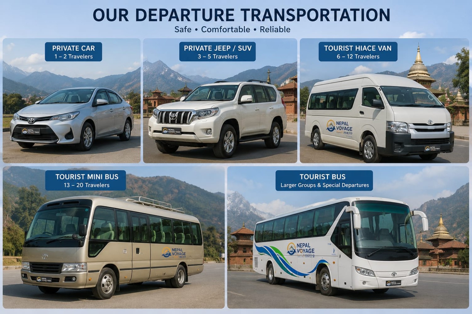
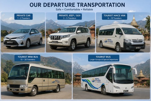
  • Private Fleet & Vehicle Allocation: Vehicle type depends on the group size (number of clients/pax):

    • 1 – 3 Pax: Private Car / Sedan

    • 4 – 6 Pax: Private SUV / Jeep / Van

    • 7 – 12 Pax: Private Toyota HiAce Van

    • 13+ Pax: Private Coaster / Tourist Bus

  • Check-in: Upon reaching the hotel, our guide will assist you with the check-in process so you can unpack, refresh, and relax after your long flight.

2. Traditional Nepali Welcome Dinner

  • Evening Plan: In the evening, your guide will pick you up from the hotel and take you to an authentic traditional Nepali restaurant.

  • The Experience: Enjoy a delicious, traditional Dal Bhat (steamed rice, lentil soup, seasonal vegetable curry, chicken/mutton or veg options, and pickles)—the famous daily fuel of Himalayan trekkers!

  • Cultural Show: The dinner is accompanied by a live cultural show featuring regional music and traditional dances from various ethnic groups of Nepal.


Accomodation: hotel
Meals: B/L/D
Duration: 30m
Day 2 — Detailed Trek Preparation & Official Pre-Trek Briefing
Ups ↑ +0 m
Down ↓ -0 m
Elevation 1350 m
Distance ⟺ 5km

Detailed Trek Preparation & Official Pre-Trek Briefing

1. Pre-Trek Briefing with the Lead Guide'

Our team will meet you at the hotel (or our office) for a comprehensive pre-trek orientation session: can buy all grars of trekking  near   your hotel  this is in centeral of touristic so not far after you chill in thamel bazar bar restaurent shop for suviner for the familly ....

  • Route Overview: Reviewing the day-by-day itinerary, trail conditions, maximum elevation gains, and daily walking hours.

  • Health & Safety First: Detailed safety briefing on Acute Mountain Sickness (AMS), prevention, recognizing symptoms, hydration protocols, and emergency evacuation procedures.

  • Environmental Responsibility: Guidelines on responsible trekking, respecting local cultures, traditions, religious sites (mani walls, stupas), and practice of "Leave No Trace."

2. Document & Permit Checking

Please ensure you bring the following to the briefing:

  • Original Passport (valid for at least 6 months) and 2–3 Passport-sized photos.

  • Travel Insurance Policy: Must explicitly state coverage for high-altitude trekking (up to the maximum elevation of your specific trek) and helicopter rescue/evacuation.

  • Permit Verification: Our team will inspect your details to issue all necessary permits (TIMS Card, National Park, or Conservation Area Permits).

3. Gear Inspection & Equipment Packing

  • Duffel Bag Distribution: Nepal Voyage Treks will provide a complimentary duffel bag (if applicable to your package) for your main luggage, which will be carried by our porters.

  • Weight Limits:

    • Porter Baggage Limit: Maximum 12 kg to 15 kg per client for the main duffel bag (carried by 1 porter shared between 2 trekkers).

    • Daypack Limit: 4 kg to 6 kg for your personal daypack (carried by yourself—containing your daily essentials: water, jacket, camera, snacks, rain gear, and passport).

  • Gear Check: Your guide will review your gear list (down jacket, sleeping bag, broken-in hiking boots, thermal layers, rain gear, trekking poles, gloves, headlamp).

  • Rental / Purchase Assistance: If you need any missing gear, your guide will take you to trusted local gear shops in Thamel to rent or buy quality equipment at reasonable prices.

4. Luggage Storage & Financial Prep

  • Extra Luggage: Any main suitcases or non-trekking clothes can be safely stored for free at your hotel's storage room or at our Nepal Voyage Treks office until you return.

  • Local Currency (NPR): ATMs are rare or non-existent on mountain trails. We will help you exchange foreign currency into Nepali Rupees (NPR) for personal expenses along the trek (extra hot showers, device charging, Wi-Fi, snacks, and guide/porter tips).


Accomodation: hotel
Meals: B/L/D
Duration: 3
Day 3 — Drive from Kathmandu to Jagat (Dolakha District)
Ups ↑ 450 m m
Elevation 1550 m
Distance ⟺ Approximately 190 km

Drive from Kathmandu to Jagat (Dolakha District)


https://images.openai.com/static-rsc-4/LenPQaUdYgP_ZFCIbqLmX-9aiNdUkKad0BzB82yjFDw6W3VKGrcne38WLGoh-XvttEs1A7lGJfTFzA1F1ChU80xtLgWJstj84F5dfzVGN3liWS30HtMT8pGx3v6cyOM99sZwul1Q_PJEEOx_n7U6NuLw6ay0ZkG4r7rHp1zgwDjmjVuH5fGnMWvXFA-aYhyi?purpose=fullsize


https://images.openai.com/static-rsc-4/QgafNOiSTlDF0N1CK-S0Z7rEbFvmKjxXvYckcjIVN6NB6mcLd5SREHsPfc4er1I9Js9vPvPoaH9zpnCkk1pTtkG4MZun2SXWw5zwYEjA6P3wHDu6FigtH-hpF18UKuP4Aaz_H4jAT4-Fo4c8q1Q5DEtHv_fCR2U_M1Wx0dJmk34sNWwgFzmZHH2JIUAcuJYH?purpose=fullsize


https://images.openai.com/static-rsc-4/B1VXCS-V-RR-kmw7EsGMOBpsGnxcau_yAulaP7qrHuTwtk4Ix0Iur2rZa3dy391n67MSXyZzoSnr41PWWcQG__Musj8itoxZexXm-F8v7FEk7WtOgHJNbQNPyc5UN1tupGIOSninqiSE1E0eL1WwStVrmApm0B7WZQXd9q-8wCds6MRJ4ztXQXNEJz7wcQuk?purpose=fullsize

6

Starting Point: Kathmandu (1,400 m)
Destination: Jagat, Dolakha (1,150 m)
Maximum Elevation: 1,550 m
Sleeping Elevation: 1,150 m
Driving Distance: Approximately 190 km
Driving Duration: 8–10 Hours
Total Ascent: +450 m
Total Descent: _700 m
Accommodation: Local Tea House / Lodge

Your Himalayan adventure begins with an exciting overland journey from Kathmandu to the peaceful village of Jagat, the traditional gateway to Nepal's beautiful Rolwaling Valley. After leaving the capital, the road follows the Bhote Koshi and Tama Koshi Rivers through picturesque countryside, terraced farms, bustling market towns, and traditional villages. The drive offers magnificent views of green hills, waterfalls, suspension bridges, and distant snow-capped mountains.

As the road climbs into the Dolakha region, travelers experience the transition from urban Nepal to rural Himalayan life. Local Tamang and Sherpa communities welcome visitors with their warm hospitality, while colorful prayer flags and hillside monasteries begin to hint at the rich Buddhist culture awaiting further along the trail.

Jagat is a quiet mountain village surrounded by forests and cultivated terraces. Here, you meet the trekking crew, organize equipment, and enjoy your first evening in the Himalayas.

Mountains Visible: Gaurishankar Range (weather permitting), surrounding Rolwaling hills.

Flora & Fauna: Pine forest, alder trees, rhododendron, Himalayan birds, monkeys, butterflies, and colorful wildflowers.

Trail / Road Condition: Mostly paved highway from Kathmandu, followed by rough mountain roads with some unpaved sections. 


Accomodation: lodge
Meals: B/L/D
Duration: 8–10 Hours
Day 4 — Trek from Jagat to Simigaun
Ups ↑ 950 m m
Elevation 2020 m
Distance ⟺ 10 km

Trek from Jagat to Simigaun


https://images.openai.com/static-rsc-4/TdbKraaxYWsx2QbNeLYa0dzMRGxCjZdj_WsaF3ilqP1MYS6aGL6OzOLfhM6bGer2mQnN2zRqJMUC6dQ3HF_QTjYZJyxhiKyDG3WQkok21DgCGFnKQTGbobRx--ZDEOPENUEHsFl1ZlvN1DMc1QBNXOF0aG6OO5vH4q1e0ZaulHzKWg0Za_-9fwyV7kpJ7Wyl?purpose=fullsize


https://images.openai.com/static-rsc-4/LZM67ga-cW0nxnUjpX83dokVVQQWFddtkjyqClyLoQs7se4-JdgHjYYSGdJt3S50IhhaqHAfd9EJoAIXTWU701Fh60WsC6wXSTAHyP8A4sajBFruYm-aa2K6egxmO6JilTNJqXjCyVU95VYfvCCyK00t9S3G8cReNrMAT9O-344olxtppstlhKnQoNjLYu1P?purpose=fullsize


https://images.openai.com/static-rsc-4/tA1LglDgdlFXm2yJ_WQD97-Uj4MYpFf8G9zL8N5lCLSZROhJl0KHaD3XQToopIPMNtV3VVP1q_-2yeZpFO0CbvQXi20ADhsos1WHyEmbciQzDSgi1HLaSvTvw2JMCIHr6OhI8zsV0oWlQd-6kbvCIT7lgzy11Cb1XdNNXLKECvsRA36ueSasgUdxSTCTehjn?purpose=fullsize

4

Starting Point: Jagat (1,150 m)
Destination: Trek from Jagat to Simigaun Maximum Elevation: 2,020 m
Sleeping Elevation: 2,020 m
Distance: 10 km
Walking Time: 5–6 Hours
Total Ascent: 950 m
Total Descent: 80 m
Accommodation: Tea House / Local Lodge

Today marks the first day of trekking. The trail follows the Tama Koshi River before climbing steadily through lush forests and charming hillside settlements. Stone staircases, terraced fields, and traditional farming villages characterize the route. As you gain altitude, magnificent views of the Rolwaling Valley begin to unfold.

Arriving at Simigaun, a beautiful Sherpa village perched high above the valley, you're rewarded with panoramic views of the surrounding mountains. Prayer wheels, ancient mani walls, and a peaceful monastery reflect the area's strong Buddhist heritage. The slower pace of life here offers a wonderful introduction to the culture of the Rolwaling region.

Mountains Visible: Gaurishankar, Melungtse, Rolwaling Himal (weather permitting).

Flora & Fauna: Rhododendron forests, oak, pine, Himalayan Monal, pheasants, langur monkeys, and wild orchids in spring.

Trail Condition: Well-established stone steps and forest trails with several steep uphill sections.

Accomodation: Lodge
Meals: B/L/D
Duration: 5–6 Hours
Day 5 — Trek from Simigaun to Dongang
Ups ↑ +900 m m
Elevation 2790 m
Distance ⟺ 12 km

Trek from Simigaun to Dongang


https://images.openai.com/static-rsc-4/po5tqu3ULUa48YZtAHHz7o26jc48xKCj55F9EfJ_IkmrX2lB8jFQYCZKLWjPjMeA8UPA964TBOq0Jvd62RP6F-Bu6gQfCN4BJKOlObYKWPiapmml-GrPqxlz4vD8XssnKHJj2JbYyiZm9ndXpp4qtaEXNzvZUCQFJGP-naj_wX4KBZ2-w-zqsQErxLA1xX0n?purpose=fullsize


https://images.openai.com/static-rsc-4/RAdxB-pPBsbY5KZPyU2LH5UmQCBWUHzRIkB_eDoEwMkD8LvOO178KAPzcAOMLOou6wX1TaUoqcV8N0lv4PT8SbRxBGXg8hWEDopxX49DZDoW3z-EOFTpoGSEq9C1WXNW2xSnbuqQCgA0M0_-_MCY2iQYsIhBXv4FgmNqZ5uTdiWq3R3zXsdJbikAxmZxM50M?purpose=fullsize


https://images.openai.com/static-rsc-4/cIyblLJDL7SwxrwHdneIbxAaYJfGsTYrlhnW2ynxVm9zAfKsL4NP2oc4MUXJVXEvlvwoa-ezXPBry7TFhsdbH0LYUx_i32Ko158mHQ8cBA-W5jp8QBlfmgc3FuGxFqCFuN-M3Uf77_zhwnZWYRHI8LAnV9JsLeo33X2Pd95YJoPRwbAhe_DQn2xC-Nj_2oDj?purpose=fullsize

4

Starting Point: Simigaun (2,020 m)
Destination: Dongang (2,790 m)
Maximum Elevation: 2,850 m
Sleeping Elevation: 2,790 m
Distance: 12 km
Walking Time: 6–7 Hours
Total Ascent: +900 m
Total Descent: _150 m
Accommodation: Basic Tea House

Leaving Simigaun, the trail enters a pristine Himalayan forest alive with birdsong and the sound of rushing streams. The path winds through bamboo groves, moss-covered trees, and narrow ridges before crossing several suspension bridges over the Rolwaling River.

The day's walk offers increasing mountain scenery as the valley narrows beneath towering cliffs. Dongang is a small seasonal settlement surrounded by dense forest and dramatic peaks, providing a peaceful overnight stop far from the crowds found on Nepal's more popular trekking routes.

Mountains Visible: Gaurishankar, Chekigo, surrounding Rolwaling peaks.

Flora & Fauna: Bamboo, birch, fir, rhododendron, Himalayan Tahr, musk deer, Himalayan griffons, and colorful pheasants.

Trail Condition: Forest paths with rocky sections, suspension bridges, and moderate climbs.


Accomodation: lodge
Meals: B/L/D
Duration: 6–7 Hours
Day 6 — Trek from Dongang to Beding
Ups ↑ +950 m m
Down ↓ -60 m
Elevation 3690 m
Distance ⟺ 11 km

Trek from Dongang to Beding


https://images.openai.com/static-rsc-4/0Dvn6c09b6HagfmPqsWtJwX8czy7jH3TGxRQaWKMeS738FLgUiHOiVB3VhrrPhhAe8WMMsXVj7L7jSbZJi6v4pYDe_Qj2XCvVTrldZxjw2V2CXs-QtP6_a8YvJpe_uAUdZEu8ZFS15-WLfCO3ksf86Ys3GddR8zKYMi5ivGBMcH_aOMtWX3XxQ4feFFtU3vm?purpose=fullsize


https://images.openai.com/static-rsc-4/dpGXXYr5X-LaMR5Wa73USStXR7Q_2y34I7Uh4mI1qemuzH15xrTgKphYpGljVmxGtlEb9vJgNH8ZFT4HUTwdzWyVkw9fRaib5uPGhOdQBkl1p-km1bmO6sWMF5Caz0Dr43QHlrqEsNeV9NDNp9CgjqXAQKQ3NVx5d_OjZK1k9H1FltJdb0BUoRNYWjVqKSyt?purpose=fullsize


https://images.openai.com/static-rsc-4/h70gXgTF1oMm0XD-zUElgRCclbR5Piq8SvqfDQW6txDK3h4dz1xg65zUpnnvc9cxy28J5C9QIfWWb30Qwby22OmLjomusGNy7KLY1VdL_iXHFyRv5rgpUsV8gygfEoh42vuA1mw52MGJBJMDD2zPaB3TULj4YrD6qpZMt7yBUoUvB0NdBbfdjiUQ5eRI4gZq?purpose=fullsize

6

Starting Point: Dongang (2,790 m)
Destination: Beding (3,690 m)
Maximum Elevation: 3,700 m
Sleeping Elevation: 3,690 m
Distance: 11 km
Walking Time: 6–7 Hours
Total Ascent: +950 m
Total Descent: _60 m
Accommodation: Tea House

Today's trek enters the heart of the Rolwaling Valley. The forests gradually give way to alpine meadows as the trail climbs beside the Rolwaling River. Spectacular waterfalls cascade from high cliffs, while snow-covered peaks dominate the skyline.

Beding is the largest Sherpa settlement in the valley and an important cultural center. Visit the ancient monastery, interact with friendly local families, and enjoy unforgettable evening views of the surrounding Himalayan giants.

Mountains Visible: Gaurishankar, Melungtse, Rolwaling Himal, Chobutse, Yalung Ri.

Flora & Fauna: Juniper, dwarf rhododendron, alpine flowers, Himalayan blue sheep, ravens, and eagles.

Trail Condition: Wide mountain trail with gradual climbing and a few rocky sections.

Accomodation: Lodge
Meals: B/L/D
Duration: 6–7 Hours
Day 7 — Trek from Beding to Na Village
Ups ↑  +550 m m
Down ↓ -40 m
Elevation 4180 m
Distance ⟺ 8 km

Trek from Beding to Na Village


https://images.openai.com/static-rsc-4/hCutBsV4K4DkfgIL4v4Q4wEcw6J-9e8lBmbdJhwgOc_6xBobvw4EdiIFwpGzd-hMiRWw5NULfpZLcdQpmfGwvlbtf5jxwxPtjpslrhYRQt2cRVTvPWLk7YS-WqjiMd1x5avVFyUpXaspYxSmApW0dnhkrJvSOzuQteIWvQTfOGPnvHtOz3C7q_RSIwKF7ZqZ?purpose=fullsize


https://images.openai.com/static-rsc-4/_uGQqLOxLJG_SQdno8Ip4hJl9yFgDGOz6k_sdKlu3yVpN9Y9-lP2I2_ZPtllYMxmCcQmA-M2Z36-GwW92JSULQG0RMDMod-BoNEEyJ525YAYvQzgc31yKjunBiwRZqQxb9-kVjLeXgs6B8XVOUIwbMfBG63o5XOCAaBfLp2LE9etAh17DpRgGMQF0NnRe9Us?purpose=fullsize


https://images.openai.com/static-rsc-4/DmvdPBLXPvYrtjosNNDr9V4srtjsYl0-Mk7gzzFORvVIoU5YROtOAoyD_bK9qYDP332I1z51oLBL0k7wq6F6tPOqHKJr9oYjRfPBzJixkXeUAHFneS1ekhMPpNjucobb6OK8IGqoHkhLwgN7WVsBxTXCHhcM3Sh_JWmiMz7eaxJlg8pQWAC_2gg2EdVEFg6Q?purpose=fullsize

4

Starting Point: Beding (3,690 m)
Destination: Na Village (4,180 m)
Maximum Elevation: 4,180 m
Sleeping Elevation: 4,180 m
Distance: 8 km
Walking Time: 4–5 Hours
Total Ascent: +550 m
Total Descent: _40 m
Accommodation: Basic Tea House / Lodge

The trek continues into high alpine country as the landscape becomes increasingly rugged and dramatic. The trail passes yak grazing pastures, glacial streams, and open valleys framed by towering Himalayan peaks. Because of the increasing altitude, today's walk is intentionally shorter, allowing your body to acclimatize properly.

Na Village is the final permanent settlement in the Rolwaling Valley and serves as an important acclimatization point before heading toward Tsho Rolpa Lake and Tashi Lapcha Pass. Surrounded by magnificent mountains and pristine wilderness, Na offers one of the most peaceful settings in the Himalayas.

As the sun sets, the snow-covered peaks glow with golden alpine light, creating an unforgettable Himalayan panorama.

Mountains Visible: Gaurishankar, Melungtse, Chobutse, Yalung Ri, Kang Nachugo, Tengi Ragi Tau.

Flora & Fauna: Alpine grasslands, medicinal herbs, juniper, blue sheep, Himalayan tahr, griffon vultures, and, occasionally, signs of snow leopard activity.

Trail Condition: Broad alpine trail with gentle climbs, glacial streams, and rocky terrain. Generally easy to moderate but slower due to the higher altitude.

Accomodation: lodge
Meals: B/L/D
Duration: 4–5 Hours
Day 8 — Acclimatization Day at Na Village (4,180 m)
Ups ↑ Gain: +470 m m
Elevation 4650 m
Distance ⟺ 7km

📷 Beautiful Photo of Na Village & Yalung Glacier

Starting Point: Na Village (4,180 m)
Destination: Na Village (4,180 m)

📍 Maximum Elevation: 4,650 m (Acclimatization Hike)

🛏️ Sleeping Elevation: 4,180 m

📏 Trekking Distance: 7 km

🕒 Walking Hours: 4–5 Hours

⬆️ Elevation Gain: +470 m

⬇️ Elevation Loss: -470 m

🥾 Difficulty: Moderate

🏡 Accommodation: Local Tea House / Mountain Lodge

🍽️ Meals: Breakfast, Lunch & Dinner

Then I will write a large detailed paragraph (400–600 words) describing:

  • Why acclimatization is important
  • The day's hiking route
  • Mountain scenery
  • Flora and fauna
  • Local culture
  • Trekking tips
  • Photography opportunities
  • Weather
  • Trail condition
  • Preparation for Tashi Lapcha Pass

At the end of each day, I'll include a professional summary like this:


🏔️ Mountains Visible

  • Gaurishankar (7,134 m)
  • Melungtse (7,181 m)
  • Chobutse (6,686 m)
  • Yalung Ri (5,630 m)
  • Tengi Ragi Tau (6,938 m)

🌺 Flora & Fauna

  • Alpine juniper
  • Dwarf rhododendron
  • Edelweiss
  • Blue Sheep
  • Himalayan Tahr
  • Himalayan Griffon
  • Snow Pigeon
  • Snow Leopard habitat

🥾 Trail Condition

The trail consists of alpine meadows, glacial moraines, yak grazing pastures, and rocky terrain. It is well suited for acclimatization, with gradual elevation gain and magnificent mountain views.

Accomodation: lodge
Meals: B/L/D
Duration: 4–5 Hours
Day 9 — Tsho Rolpa Camp chhukiyma (4,550 m) → Trakarding Glacier Camp (4,650 m)
Ups ↑ Elevation Gain: +250 m m
Down ↓ -150 m
Elevation 4500 m
Distance ⟺ 📏 Distance: 5–6 km


https://images.openai.com/static-rsc-4/ssaGYQpnjrLIFAhMHWJbLTXeWne-uFT1kD2HxvkqFSY6dYcWLScFN9AVGxO4BI-gYksfYAXihIwcxA-95eVaSJAo1Qdr4QMzL5DE-HRnXBWUK3emIovoRL2bAvJP9pwRR5y-352puUHjeCKxxDpwcKueMfvEVyVjaJ6kLt4oPalWaLqu5uNQ85_QJvlUg_oZ?purpose=fullsize


https://images.openai.com/static-rsc-4/7gi1USK6dYU_HB6foeF50myx_wo9mgeKwaOwrZ-Z4GTfvxn4rWZ67dkwviGSudIoVTCMuVDMJ4HyPfsla0NBBJjtzUPx7xTv2vO9G7V4c2YpmAEVCIdyRBmw-IGiYuXVXR9Sn4dPrJhBi4HSvCqySyChLki3Ru3Bz1RWSVzyVpjpyZf2GhY5MJ4AnAtJv_i9?purpose=fullsize


https://images.openai.com/static-rsc-4/17iSlwLY2kKoXXtbWNi8hQcCAmHyXmJ2gWfimXi1JYcRzlhOJZ0prYfgmx_uXsbKwhvEuxhJ6PNgfG6jC-6BrAOXu-GK9FTBKhaSXOWL3QXGXK5q2qBQg0jr3FPFKX-y9d9vZCQNp9_fKtSL8IwArtZBfiybHTj_bCVO9wsD4cReVCagQP2Rd4RfoHcMuUdk?purpose=fullsize

5

Trekking Information

Starting Point: Tsho Rolpa Camp (4,550 m)
Destination: Trakarding Glacier Camp (4,650 m)

📍 Maximum Elevation: 4,750 m
🛏️ Sleeping Elevation: 4,650 m

📏 Distance: 5–6 km
🕒 Walking Duration: 4–5 Hours

⬆️ Elevation Gain: +250 m
⬇️ Elevation Loss: -150 m

Difficulty: Challenging

🏕️ Accommodation: Tent Camping

🍽️ Meals: Full camping meals


Day Description

Today is a shorter but very important high-altitude trekking day. Leaving the beautiful Tsho Rolpa Lake behind, we continue deeper into the upper Rolwaling Valley toward the remote Trakarding Glacier area.

The trail crosses rugged glacial landscapes, rocky moraines, and isolated mountain terrain. The surrounding environment becomes more dramatic as we approach the base of Tashi Lapcha Pass (5,755 m).

The shorter walking distance allows trekkers to conserve energy for the next major challenge: crossing Tashi Lapcha Pass. The climbing guide will check equipment, explain glacier safety, and prepare the team for the upcoming high pass crossing.

The campsite near Trakarding Glacier provides an authentic Himalayan expedition experience, surrounded by glaciers, ice-covered peaks, and complete wilderness.

Accomodation: tent
Meals: B/L/D
Duration: 4–5 Hours
Day 10 — Chukyima Camp (4,900 m) → Trakarding Glacier / Jabou High Camp (5,300 m)
Ups ↑ ⬆️ Ascent (Elevation Gain): +400 m m
Elevation 4900 m
Distance ⟺ Distance: 5–7 km

Upper Rolwaling Valley Glacier Expedition – Final Approach Before Tashi Lapcha Pass


https://images.openai.com/static-rsc-4/KjDABF9_SO0jrbCoZ9Oqr9hxQAtFMcSgLTkZiQOcxn38-UVrT-2EHgKdQyLI8GxbgnudplsMzKRvVz9tIFq36Tvxi6ghdERjbAAwAmLC5Sqq_ITul93yywFEkuLZh97U19PDerw244VbmRhAL8rV_vlqsbeBUZuZPp10szBfUK9pgv4MDbv7-CNlBd4crG-n?purpose=fullsize


https://images.openai.com/static-rsc-4/ssaGYQpnjrLIFAhMHWJbLTXeWne-uFT1kD2HxvkqFSY6dYcWLScFN9AVGxO4BI-gYksfYAXihIwcxA-95eVaSJAo1Qdr4QMzL5DE-HRnXBWUK3emIovoRL2bAvJP9pwRR5y-352puUHjeCKxxDpwcKueMfvEVyVjaJ6kLt4oPalWaLqu5uNQ85_QJvlUg_oZ?purpose=fullsize


https://images.openai.com/static-rsc-4/egNZoGH8ZWTlX_TcISW3kQJS5D-gJmta26FMOKKW1FjMX5CWuvpJTu7s6BsMbHLLGOm8c0RR4TMLOZtf9wg8RNCvWIIrjYtjUrFjKdEoZQjkHdn_nY2Ub32gznVIcvhMhdzPcnriBnQ9xVRIKz5nAcOukL0elK8_VAsjy7SUcChaSknJHzClBsvbXiPeLLFo?purpose=fullsize

6


Trekking Information

Route: Chukyima Camp → Trakarding Glacier → Jabou High Camp

Starting Elevation: 4,900 m
Final Elevation / Sleeping Camp: 5,300 m

📍 Maximum Elevation: 5,300 m

📏 Distance: 5–7 km

🕒 Walking Duration: 5–6 hours

⬆️ Ascent (Elevation Gain): +400 m

⬇️ Descent (Elevation Loss): -100 m

🥾 Difficulty: Challenging – High Altitude Glacier Trekking

🏕️ Accommodation: High Altitude Tent Camping

🍽️ Meals: Breakfast, packed lunch, dinner prepared by expedition cook

🏔️ Mountain Views

From Chukyima to Jabou High Camp, trekkers can enjoy spectacular Himalayan scenery:

🏔️ Gaurishankar Himal (7,134 m)
🏔️ Melungtse (7,181 m)
🏔️ Tengi Ragi Tau (6,938 m)
🏔️ Chobutse (6,686 m)
🏔️ Pachermo Peak (6,273 m)
🏔️ Yalung Ri (5,630 m)
🏔️ Rolwaling Himalayan Range

The surrounding peaks create an incredible high mountain panorama, especially during sunrise and sunset.


🌺 Flora and Fauna

At 5,300 m, the ecosystem is extremely limited because of cold temperatures and strong winds.

Flora (Plants)

Possible vegetation:

  • Alpine grasses
  • Moss
  • Lichen
  • Small hardy Himalayan plants
  • High-altitude medicinal herbs

There are no forests at this elevation.


Fauna (Wildlife)

Possible sightings:

🦌 Himalayan Blue Sheep (Bharal)
🦌 Himalayan Tahr
🐦 Snow Pigeon
🐦 Himalayan Griffon
🐦 Lammergeier (Bearded Vulture)
🐦 Ravens

The upper Rolwaling Valley is also a protected habitat area for the rare Snow Leopard, although sightings are extremely uncommon.


🥾 Trail Condition

Today's trail is a remote high-altitude route.

The route includes:

✅ Rocky moraine trails
✅ Glacier debris
✅ Loose rocks
✅ Steep mountain sections
✅ Snow and ice patches (depending on season)

The trail condition can change quickly because of:

  • Fresh snowfall
  • Strong wind
  • Temperature changes
  • Glacier movement

Trekkers should use:

  • Good quality trekking boots
  • Trekking poles
  • Warm layers
  • Sunglasses
  • Gloves
  • Sunscreen

🏕️ Camping & Sleeping Arrangement

There are no lodges or tea houses beyond Chukyima. Nepal Voyage Treks provides a complete expedition-style camping arrangement.

High Camp Facilities

✅ Sleeping tents
✅ Dining tent
✅ Kitchen tent
✅ Sleeping mattresses
✅ Warm sleeping bags
✅ Hot meals
✅ Hot drinks
✅ First aid equipment
✅ Professional trekking and climbing crew

The camping crew carries all necessary equipment to make this remote section comfortable and safe for international clients.


🍽️ Meals at High Camp

Breakfast:

  • Tea / coffee
  • Porridge
  • Eggs
  • Bread
  • Tibetan bread

Lunch:

  • Soup
  • Rice or noodles
  • Vegetables
  • Energy snacks

Dinner:

  • Dal Bhat
  • Pasta
  • Soup
  • Vegetables
  • Hot drinks

High-energy food helps maintain strength at extreme altitude.


⚠️ Safety & Acclimatization

Sleeping at 5,300 m requires careful altitude management.

The guide checks:

  • Oxygen saturation
  • Headache symptoms
  • Breathing
  • Appetite
  • Energy level
  • Weather conditions

Trekkers should:

✅ Walk slowly
✅ Drink plenty of water
✅ Keep warm
✅ Eat properly
✅ Inform the guide immediately about discomfort

This day prepares the team for one of the biggest highlights of the expedition:

Accomodation: tent
Meals: B/L/D
Duration: 5–6 hours
Day 11 — Trakarding Glacier / Jabou High Camp (5,300 m) → Tashi Lapcha Pass (5,755 m) → Tashi Phuk Camp (5,100 m)
Ups ↑ ⬆️ Ascent (Elevation Gain): +455 m m
Elevation 5700 m
Distance ⟺ Distance: 8–10 km

Crossing the Legendary Tashi Lapcha Pass – The Highest and Most Challenging Day of the Expedition


https://images.openai.com/static-rsc-4/-j5FdnZ6HPIlTxrgmbUFmtcEhub_diRsbZcAg90ptm0na1RnzsNKuziNVGwcut0rRhzbFLTEmHh3Ii2TDSqgzy4T3PAUm4f59TlTmPz_WzWEVXDXPQTFDDqegxzsxmPBMxPnm1Igj9fbjYUCJXYf3dDo3HtxhIM23ok7SaT2TiyRWyne4qwM0BhexIEw5UYv?purpose=fullsize


https://images.openai.com/static-rsc-4/TMoIIu1Y-aDeNuS3GnQgzv1pasTfcznxLK6WZOHa5OCP4oSVtvxeDqGxUnBD1XiRCqBU0lEOwMADMoWxkz01Bk5_VtgHF8XM9bWZ652gxdLKzifcJtLU9fyX0q9n_nADU8uv1EXiWn6hD_QCU0s9shkpy6pB6RbB5GLPN3miVE94yqH2DzMQKw8GMlofswii?purpose=fullsize


https://images.openai.com/static-rsc-4/BjSst32dYNE3jHGc-HbJY1NquWSOUvyWhQGpXW3DZ3r1C16QdpCqZw8oKgFMRy_z1Bn45hV6CjbrGc-zs7s2z0b6iY3OLfNKwmbDJnlgBB6Nu7E2u_usI36CgcQkZtf1HCCAX7MSWuY8FGL50BbNfiQ2cjqn50C81b_Hc2IlQMzxK1ntyaKuF-pYl6xsEPE8?purpose=fullsize

7


Trekking Information

Route: Jabou High Camp → Tashi Lapcha Pass → Tashi Phuk Camp

Starting Elevation: 5,300 m
Highest Point: Tashi Lapcha Pass – 5,755 m
Sleeping Elevation: 5,100 m

📍 Maximum Elevation: 5,755 m

📏 Distance: 8–10 km

🕒 Walking Duration: 8–10 hours

⬆️ Ascent (Elevation Gain): +455 m

⬇️ Descent (Elevation Loss): -655 m

🥾 Difficulty: Very Challenging – High Altitude Glacier Crossing

🏕️ Accommodation: Tent Camping at Tashi Phuk Camp

🍽️ Meals: Early breakfast, packed lunch, dinner at camp


Day Description

Today is the most adventurous and demanding day of the entire Rolwaling Valley – Pachermo Peak Climbing – Everest Base Camp Expedition. The team leaves Jabou High Camp (5,300 m) very early in the morning and begins the ascent toward the spectacular Tashi Lapcha Pass (5,755 m).

An early start is essential because morning temperatures provide firmer snow conditions and safer glacier travel. After breakfast, the climbing guide prepares everyone with necessary equipment:

  • Mountaineering boots
  • Crampons
  • Ice axe
  • Harness
  • Helmet
  • Safety rope

The route gradually climbs through the frozen upper Rolwaling landscape. The trail crosses glacier sections, snow slopes, and rocky mountain terrain. The thin air at this altitude requires a slow and careful walking rhythm.

As the team approaches Tashi Lapcha Pass (5,755 m), the views become increasingly spectacular. Standing on the pass is a remarkable achievement, with panoramic views of the Rolwaling Himalaya and the Khumbu mountain range.

The pass represents the natural gateway between the remote Rolwaling Valley and the famous Everest region. After enjoying the breathtaking scenery and taking photographs, the team begins the descent toward Tashi Phuk Camp (5,100 m).

The descent requires careful attention because of:

  • Loose rocks
  • Snow sections
  • Tired muscles after the high pass
  • Changing weather conditions

Upon arrival at Tashi Phuk Camp, the expedition crew prepares a warm meal and a comfortable campsite. This evening is a special moment because the team has successfully completed one of Nepal's most impressive high-altitude crossings.


🏔️ Mountain Views

From Tashi Lapcha Pass, trekkers can see an incredible Himalayan panorama:

🏔️ Gaurishankar (7,134 m)
🏔️ Melungtse (7,181 m)
🏔️ Tengi Ragi Tau (6,938 m)
🏔️ Pachermo Peak (6,273 m)
🏔️ Khumbu Himalayas
🏔️ Everest Region Peaks
🏔️ Cho Oyu (8,188 m) (possible in clear weather)

The view from Tashi Lapcha Pass is considered one of the finest hidden viewpoints in Nepal.


🌺 Flora and Fauna

At 5,500 meters and above, life is extremely limited.

Flora

  • Lichen
  • Moss
  • Small alpine plants
  • Hardy mountain grasses

Fauna

Possible sightings:

🦌 Himalayan Blue Sheep
🦌 Himalayan Tahr
🐦 Snow Pigeon
🐦 Himalayan Griffon
🐦 Lammergeier
🐦 Ravens

Snow Leopard habitat exists in this region, but sightings are extremely rare.


🥾 Trail Condition

Today is the most technical trekking section.

The route includes:

✅ Glacier crossing
✅ Snow-covered slopes
✅ Ice sections
✅ Rocky moraine
✅ Steep descent

Depending on season and weather, conditions may require:

  • Crampons
  • Rope assistance
  • Ice axe
  • Technical guidance

Professional guiding is essential for safety.


🏕️ Accommodation – Tashi Phuk Camp (5,100 m)

After crossing the pass, the team stays at a remote mountain campsite.

Nepal Voyage Treks provides:

✅ Sleeping tents
✅ Dining tent
✅ Kitchen tent
✅ Sleeping mattresses
✅ Warm sleeping bags
✅ Hot meals
✅ First aid support
✅ Experienced climbing staff

This night is spent enjoying the peaceful Himalayan wilderness before continuing toward Pachermo Base Camp.


🍽️ Meals

Early Breakfast:

  • Tea/coffee
  • Porridge
  • Eggs
  • Bread

Packed Lunch:

  • Sandwich
  • Energy snacks
  • Chocolate
  • Juice

Dinner:

  • Dal Bhat
  • Pasta
  • Soup
  • Vegetables
  • Hot drinks

⚠️ Safety & Client Information

For international clients, this day requires:

✅ Good physical fitness
✅ Previous high-altitude trekking experience
✅ Proper acclimatization
✅ Professional guide support
✅ Correct climbing equipment

The guide monitors:

  • Altitude symptoms
  • Weather
  • Snow conditions
  • Group energy level

Safety is always the first priority.

Accomodation: tent
Meals: B/L/D
Duration: Walking Duration: 8–10 hours
Day 12 — Tashi Phuk Camp (5,100 m) → Pachermo Peak Summit (6,273 m) → Back to Tashi Phuk Camp (5,100 m)
Ups ↑ Ascent (Elevation Gain): +1,173 m m
Elevation 6273 m
Distance ⟺ 📏 Distance: Approximately 10–12 km round trip


Pachermo Peak Climbing Day – Summit Adventure in the Rolwaling Himalaya


https://images.openai.com/static-rsc-4/jqidL_gy1KUouZ4Rfwm1cY9S8Qw9N0VW5EtP5kj31L1Em84Lj9BSmXH85t7iihMUxlu404yggsC-2gXx_gaEN7V3p0dQA0k7XuiE8IIATLHzcrws7w3mtDN6r88glMAdkrYK9L_FgYHtraikvGgi1lGDifm4gRggc-IqiC_o34AiqtJ_r4U_zmXMNTQvXuqv?purpose=fullsize


https://images.openai.com/static-rsc-4/YvBfWxWncsJEpFSQEWsXJufAOBu3oh8lc6ig-Na42LGtcjUFLxDxzdc1HqvamWW1dQP9yV1lmFeTGKKuza1H_yLOaO689BvzvFGw2zNS1WgQLYJ5I7CfBu7omz1m3WHBAZt0RMPP58ievnSzE9L3qvDaQJv-Nm04pZ1uOJ3d9cw_ZSQCyIU6D0zKOoOqodst?purpose=fullsize


https://images.openai.com/static-rsc-4/DPPaR8vdBduuqbQXYb4nlsCQowDQL6j28h9y_nuwSuTTmoYOhnFCGMBl4laJutjT5hNVY1r9kDJyLbt09nHggvrPt9gDOHARhoOkw2vk9ODcseZoRpRNRSCduE3MwUATP6zgmHvfE9UNyq-xHlQXhCt18XcfuuIP_OaYYSH-PsAOG4YNlOHgPRKr1xCkIAUK?purpose=fullsize

6


Climbing Information

Route: Tashi Phuk Camp → Pachermo Peak Summit → Tashi Phuk Camp

Starting Elevation: 5,100 m
Summit Elevation: 6,273 m
Sleeping Elevation: 5,100 m

📍 Maximum Elevation: 6,273 m (Pachermo Peak Summit)

📏 Distance: Approximately 10–12 km round trip

🕒 Climbing Duration: 10–12 hours

⬆️ Ascent (Elevation Gain): +1,173 m

⬇️ Descent (Elevation Loss): -1,173 m

🥾 Difficulty: Challenging Technical Alpine Climb

🏕️ Accommodation: Tent Camping at Tashi Phuk Camp

🍽️ Meals: Early breakfast, packed lunch/snacks, dinner at camp


Day Description

Today is the highlight of the climbing section of the expedition — the Pachermo Peak summit day. From Tashi Phuk Camp (5,100 m), the team makes an early morning start, usually before sunrise, to take advantage of stable weather and better snow conditions.

After a light breakfast, the climbing guide prepares the team and checks all climbing equipment:

  • Mountaineering boots
  • Crampons
  • Ice axe
  • Climbing harness
  • Helmet
  • Safety rope
  • Warm layers

The route begins across high-altitude glacier terrain and gradually climbs toward the upper slopes of Pachermo Peak (6,273 m). The ascent becomes more demanding as the altitude increases. The thin air, steep snow slopes, and cold temperatures require a slow and steady climbing pace.

The climb involves glacier travel and steep snow sections where the guide may use fixed rope or safety rope techniques depending on the season and mountain conditions. Previous high-altitude experience and good physical fitness are important for a successful summit attempt.

After several hours of climbing, the team reaches the summit of Pachermo Peak (6,273 m). Standing on the summit provides an unforgettable Himalayan panorama. The surrounding mountains appear endless, with spectacular views across the Rolwaling and Khumbu regions.

After celebrating the summit achievement and taking photographs, the team carefully descends back to Tashi Phuk Camp (5,100 m). The descent requires concentration because tiredness and altitude can make the trail more challenging.

After reaching camp, the crew prepares a warm meal and trekkers enjoy a well-earned rest after completing one of Nepal's great Himalayan climbing experiences.


🏔️ Mountain Views from Pachermo Summit

From the summit, depending on weather conditions, climbers can see:

🏔️ Mount Everest (8,848.86 m)
🏔️ Lhotse (8,516 m)
🏔️ Cho Oyu (8,188 m)
🏔️ Makalu (8,485 m)
🏔️ Gaurishankar (7,134 m)
🏔️ Melungtse (7,181 m)
🏔️ Tengi Ragi Tau (6,938 m)
🏔️ Ama Dablam (6,812 m)
🏔️ Khumbu Himalayan Range

The summit provides one of the finest viewpoints between the Rolwaling and Everest regions.


🌺 Flora and Fauna

Because the climbing route is above 5,000 m, vegetation is almost absent.

Flora

  • Lichen
  • Moss
  • Small alpine plants
  • Hardy high-altitude grasses

Fauna

Possible sightings around lower sections:

  • Himalayan Blue Sheep (Bharal)
  • Himalayan Tahr
  • Snow Pigeon
  • Himalayan Griffon
  • Lammergeier
  • Ravens

The upper Rolwaling region is also a habitat area for the rare Snow Leopard.


🥾 Trail & Climbing Conditions

The route includes:

✅ Glacier walking
✅ Snow slopes
✅ Rocky sections
✅ Steep alpine terrain
✅ High altitude climbing sections

Conditions depend on:

  • Snow quality
  • Weather
  • Season
  • Temperature

The guide decides the safest climbing route according to current mountain conditions.


🏕️ Sleeping Arrangement – Tashi Phuk Camp (5,100 m)

After the summit, the team returns to the same expedition camp.

Camping facilities:

✅ Sleeping tents
✅ Dining tent
✅ Kitchen tent
✅ Sleeping mattress
✅ Warm sleeping bags
✅ Hot meals
✅ Hot drinks
✅ First aid equipment

The camping crew provides full support throughout the climbing period.


🍽️ Food Plan

Before Climb:

  • Tea/coffee
  • Porridge
  • Eggs
  • Bread
  • Energy food

During Climb:

  • Chocolate
  • Energy bars
  • Dry fruits
  • Packed snacks
  • Hot drinks

After Summit:

  • Dal Bhat
  • Pasta
  • Soup
  • Vegetables
  • Hot drinks

⚠️ Safety Information for International Clients

Pachermo Peak climbing requires:

✅ Good physical fitness
✅ Previous trekking experience above 5,000 m
✅ Proper acclimatization
✅ Professional climbing guide
✅ Technical equipment

The climbing guide monitors:

  • Weather conditions
  • Altitude symptoms
  • Energy level
  • Snow conditions

The summit attempt is always dependent on safety and mountain conditions.

Accomodation: tent
Meals: B/L/D
Duration: 🕒 Climbing Duration: 10–12 hours
Day 13 — Tashi Phuk Camp (5,100 m) → Thyangbo (4,350 m)
Ups ↑ ⬆️ Ascent: +150 m m
Elevation 4350 m
Distance ⟺ Distance: 8–10 km


https://images.openai.com/static-rsc-4/vGwHn5o48tflnJGhSXaZsZKzL8HQEZOyloK6-oJvdZkdllk4T9cqZA5VC0vjpEyepHZhojIIwlxDVVpETiFaV_E0cKC2Q9he2E4KgOlkhhwta8Z8PhSbmFgWO6aAhZaJlx4HxOc-Kb_dAnnG3Kgxr6zrCBVATrdEYk-Wtc-X6mrRglshczvfWihigkgEHa3g?purpose=fullsize


https://images.openai.com/static-rsc-4/4JJLC4-fuB3qDaqfqv60WLHy3OAQQwMcCNrkx7EOjSq0RXEOIFIeMouuEm7btdp6jElDvh1daHjd9GLmwicZJArgJmX5w0gqv6uOHNrOVSM2734ynxRI7yUrTkwCyqryKddlZxnu9zVp4E74rIY9e8B98uhvqif8t2A1wLjTe-7I7vRdU29E7dMEbeI1WWS6?purpose=fullsize


https://images.openai.com/static-rsc-4/4zR2yEQWSH02qiopkRcIM5GoZI87itK5DBrcJbU2cyPdFKgIOeXCyt0JdwG8aIdq-XWo3UFggc93JXkGUb283Yac5fC2pGtyOCu7wrTHm0fDUm9SA3NOnull8P6Ld-hR84mmoM_JAxNTbTy3EJuHsjcfBX4GGkPuFpi3izKA0hBLNg_DWPWFpD7FDjQu2toU?purpose=fullsize

5

Trekking Information

  • Starting Point: Tashi Phuk Camp – 5,100 m
  • Destination: Thyangbo – 4,350 m
  • Sleeping Elevation: 4,350 m
  • Distance: 10–12 km
  • Walking Duration: 6–7 hours
  • Ascent: Approximately +150 m
  • Descent: Approximately -900 m
  • Difficulty: Moderate to Challenging
  • Accommodation: Tent Camp (Camping)
  • Meals: Breakfast, Lunch, and Dinner

Leaving the remote campsite of Tashi Phuk (5,100 m), today's journey follows one of the most spectacular alpine valleys in the Rolwaling region as you descend toward the beautiful grazing meadows of Thyangbo (4,350 m). After crossing rugged glacial terrain and rocky moraines below Tashi Lapcha Pass (5,755 m), the trail gradually becomes easier, leading into wide yak pastures, crystal-clear streams, and peaceful alpine landscapes. The descent offers welcome relief after the demanding high-pass crossing while still providing unforgettable Himalayan scenery throughout the day.

As you lose elevation, the surrounding landscape changes from barren glacial terrain to vibrant alpine meadows filled with seasonal wildflowers during spring and summer. The area is rich in Himalayan flora, including dwarf rhododendron, Himalayan juniper, alpine grasses, primulas, gentians, edelweiss, and colorful mountain flowers that bloom during the warmer months. Lower sections of the valley begin to feature scattered birch and rhododendron shrubs, adding more greenery to the landscape.

The remote wilderness surrounding Thyangbo is also home to a remarkable variety of Himalayan wildlife. Trekkers may spot Himalayan Thar, Blue Sheep (Bharal), Musk Deer, Himalayan Marmots, and, with exceptional luck, signs of the elusive Snow Leopard that inhabits these high mountains. Bird enthusiasts can often observe the colorful Himalayan Monal, Nepal's national bird, along with Blood Pheasants, Snow Pigeons, Yellow-billed Choughs, and Golden Eagles soaring above the cliffs.

Throughout today's trek, spectacular mountain panoramas dominate the skyline. On clear days, trekkers enjoy magnificent views of Pachermo Peak (6,273 m), Dragkar-Go (6,793 m), Tengi Ragi Tau (6,938 m), Bigphero Go Shar (6,672 m), and numerous snow-covered peaks surrounding the Rolwaling and Khumbu Himal. The dramatic contrast between towering glaciers, rugged cliffs, turquoise streams, and lush alpine meadows makes this one of the most photogenic days of the expedition.

The trail consists mainly of rocky mountain paths, glacial moraine, alpine grassland, and gentle descents across open valleys. Although some sections remain uneven and require careful footing, the route is considerably easier than the previous day's pass crossing. Reaching Thyangbo Camp rewards trekkers with a peaceful campsite surrounded by breathtaking Himalayan scenery, where yaks graze across wide alpine meadows beneath snow-capped peaks. It is an ideal place to relax, enjoy the tranquility of the mountains, and reflect on the successful crossing of the legendary Tashi Lapcha Pass.

Why Trek with Nepal Voyage Treks?

With Nepal Voyage Treks, every adventure is led by experienced local mountain guides who know the hidden trails, mountain culture, and changing conditions of the Himalayas. We provide quality camping equipment, professional climbing support, nutritious meals, and personalized service to ensure your journey through the remote Rolwaling Valley and Tashi Lapcha region is safe, comfortable, and truly unforgettable.

Website: www.nepalvoyagetreks.com

Accomodation: lodge
Meals: B/L/D
Duration: Walking Duration: 6–7 hours
Day 14 — Thyangbo (4,350 m) → Thame Teng (4,000 m) → Thame Village (3,800 m)
Ups ↑ +150 m m
Elevation 4350 m
Distance ⟺ 📏 Distance: 8–10 km


Entering the Traditional Sherpa Heritage of the Khumbu Region


https://images.openai.com/static-rsc-4/f7Ii3gCYqPcystDVdzy7zWx64CYr_dqIpaK7PQ66ALMtSGhtXgNvXgX33HLt4ifdTjvFTkAcI-prkiSZOicAWGO9XAcD_ZwnAgSyF-fltQd0fXYBy-w2lABslwwLZ7rKLX37bfNguW0hw80wWdKbDqY_zBmOBFUfNWHwlgF1cYy7jspw5ZhWpw1oDHrd_yHS?purpose=fullsize


https://images.openai.com/static-rsc-4/2fOcHDzAXfizPYLwfNy0-JTSXqpbgikeGlVYbAyw7jODcRNwkhMj9n7TI5Fjb3WGH26K1RJSRTPGRdmNxStfTBwJ9_JNJvuMkpD7HOrcrTRt76eyhLD-6U1pS_WCs8ej0If-vRSb9DKseMZmMZZuV320h78kqfS3vx9_GBJTJ92Bmef5FuGBk4jcQ-O-aCpk?purpose=fullsize


https://images.openai.com/static-rsc-4/O9myKXQOiq4WUL3_QhPH504TSMazzXQbq6lMBCOzu95z4jf9CT-VqC-EUXJV10NEkoF7l4bvebVoFzvqZQ05Bi111WoXNxtlIJqn1boZkSVLZQ1PKJEqa-LKOI_H7PE9Q3G0Fuc3Je8f55Ge-avgAE1WYH7cgGHBujt_-LaHlynKhdixD2T3Rm_U6Fh7blSc?purpose=fullsize

5


Trekking Information

Route: Thyangbo → Thame Teng → Thame Village

Starting Elevation: 4,350 m
Destination: Thame Village (3,800 m)📍 Maxim
um Elevation: 4,350 m🛏️ Sleeping Elevation: 3,800 m

📏 Distance: 8–10 km

🕒 Walking Duration: 5–6 hours

⬆️ Ascent (Elevation Gain): +150 m

⬇️ Descent (Elevation Loss): -550 m

🥾 Difficulty: Moderate Trekking Day (Recovery & Cultural Experience Day)

🏕️ Accommodation: Local Tea House / Lodge

🍽️ Meals: Breakfast, Lunch & Dinner at Lodge


Day Description – What We Are Doing Today

After spending several challenging days in the high Himalayan region, including Tashi Lapcha Pass crossing and Pachermo Peak climbing, today is a relaxing but culturally rewarding trekking day. We leave the remote Thyangbo area (4,350 m) and gradually descend toward the famous Sherpa settlement of Thame Village (3,800 m).

After breakfast, we start walking through the peaceful mountain landscape. The trail follows the traditional route connecting the remote valleys of Rolwaling and Khumbu. Compared with the glacier and climbing sections, today’s route is easier, allowing trekkers to recover while enjoying the natural beauty of the Himalayas.

The trail passes through open alpine landscapes, yak grazing areas, rocky mountain slopes, and traditional Sherpa countryside. As we lose altitude, the environment changes gradually:

  • Snow and glacier landscapes become distant
  • More green vegetation appears
  • Small bushes and alpine forests return
  • Traditional stone houses become visible

During the walk, we enter the heart of Sherpa culture. The Thame Valley is one of the oldest settlements in the Everest region and has a strong connection with Himalayan mountaineering history.

Upon reaching Thame Teng, we take a rest break and enjoy the peaceful surroundings. From here, the trail continues gradually downhill toward Thame Village, one of the most beautiful and culturally important villages in the Khumbu region.

Thame is famous for:

  • Traditional Sherpa lifestyle
  • Ancient Buddhist culture
  • Historic monasteries
  • Birthplace of many famous Himalayan climbers
  • Beautiful mountain scenery

In the afternoon, trekkers have time to explore the village, visit local monasteries, walk around traditional houses, and experience authentic Sherpa hospitality.

Tonight we stay in a comfortable tea house after many nights of high-altitude camping.


🏔️ Mountain Views

During today's trek, possible mountain views include:

🏔️ Tengi Ragi Tau (6,938 m)
🏔️ Kusum Kanguru (6,367 m)
🏔️ Kwangde Himal
🏔️ Thamserku (6,623 m)
🏔️ Khumbu Himalayan Range

The views become wider as we descend toward Thame Valley.


🌺 Flora and Fauna

As we descend below 4,000 m, the Himalayan ecosystem becomes richer.

Flora (Plants)

You can see:

🌲 Juniper bushes
🌲 Rhododendron shrubs
🌲 Alpine grasses
🌲 Birch trees (lower areas)
🌱 Himalayan medicinal plants

Fauna (Wildlife)

Possible sightings:

🦌 Himalayan Tahr
🦌 Musk Deer
🐐 Himalayan Blue Sheep
🐦 Himalayan Monal (Danphe)
🐦 Himalayan Griffon
🐦 Snow Pigeon


🥾 Trail Condition

Today's trail is mostly a comfortable mountain route.

The trail includes:

✅ Rocky downhill paths
✅ Yak pasture trails
✅ Stone steps near villages
✅ Mountain side paths
✅ Forest sections near lower elevations

Compared with the previous glacier sections, this route is easier, but trekkers should still walk carefully because of:

  • Loose stones
  • Uneven ground
  • Tired legs after climbing

🏡 Accommodation – Thame Village Lodge (3,800 m)

Tonight we return to tea house accommodation.

Facilities:

✅ Comfortable rooms
✅ Dining room
✅ Warm meals
✅ Hot tea/coffee
✅ Charging facilities (depending on lodge)
✅ Traditional Sherpa hospitality

Sleeping in a lodge provides good recovery before continuing toward Lumde and Renjo La Pass.


🍽️ Meals

Breakfast:

  • Tea/coffee
  • Eggs
  • Bread
  • Porridge

Lunch:

  • Dal Bhat
  • Noodles
  • Soup
  • Vegetables

Dinner:

  • Traditional Nepali food
  • Pasta/rice dishes
  • Soup
  • Hot drinks

🌍 Experience for International Clients

Today gives trekkers a different Himalayan experience:

⭐ Recovery after high-altitude climbing
⭐ Authentic Sherpa village life
⭐ Buddhist culture and monasteries
⭐ Beautiful Khumbu mountain scenery
⭐ Comfortable lodge stay after camping

This day is important because it connects the adventurous climbing section with the next major challenge:

Accomodation: lodge
Meals: B/L/D
Duration: 🕒 Walking Duration: 5–6 hours
Day 15 — Thame Village (3,800 m) → Thame Teng (4,000 m) → Lumde (4,380 m)
Ups ↑ +600 m m
Elevation 4380 m
Distance ⟺ 10–12 km

Approaching Renjo La Pass Through the Remote Nangpa Valley


https://images.openai.com/static-rsc-4/nQUqmfxrfKGX2gFM3ok3n4plw3Civcnnyblm6xzVIC0f17mYeKUUrMfsyk9HVHEaebWmTh7bkylvWuNy9Q1c-vE3j3lezauKt44g_n9mve_X-WJiQuPq-MZnrwD3N5xCAVDJjn8UKYGt8dfe1mkrH6vAiBuOSS0kmDSayPbFOpU6i2hZcoITK8CWWAJBPNuv?purpose=fullsize


https://images.openai.com/static-rsc-4/4j1OHzHWi6cssnPqKw-4nmvkaIfnBoz84Rmup5dTZA8Vv-QHKu68lDvoT8ideA3AYR5p4DKZACKqa17vx26E7CkERd3uAg-C70fOWrBIhHVN2Gt1IvXenVlE-q2pAAVUxqlnD5Z3TgnYLDB7F2cX1g77RaH306Goo3SY6vi3ybKazPDDWsS4FSwFREleInhA?purpose=fullsize


https://images.openai.com/static-rsc-4/5MyuW00rxGjF1bL1c5soBNY7fYLfXRYU4d2ZYUhvFlUJGz-a1wam6eL3JrCVuTFV0WASSsbGunmWTX4hU6E2eGLGhFKxlhfMAgM9H09SG6Sh5oRMt4DHfx_IHv1UVSAufhsx_SpDY4FIhlVpz7zbvs6ap33OqhJj2VpwBVT6nzqpcMiPpQIZI0zvyWqqkm5U?purpose=fullsize

6


Trekking Information

Route: Thame Village → Thame Teng → Lumde

Starting Elevation: 3,800 m
Destination: Lumde (4,380 m)

📍 Maximum Elevation: 4,380 m

🛏️ Sleeping Elevation: 4,380 m

📏 Distance: 10–12 km

🕒 Walking Duration: 5–6 hours

⬆️ Ascent (Elevation Gain): +600 m

⬇️ Descent (Elevation Loss): -50 m

🥾 Difficulty: Moderate to Challenging (High Altitude Trekking)

🏕️ Accommodation: Tea House / Lodge

🍽️ Meals: Breakfast, Lunch & Dinner at Lodge


Day Description – What We Are Doing Today

After enjoying the traditional Sherpa culture of Thame Village, today we continue deeper into the remote mountain valley toward Lumde (4,380 m). This day prepares us for one of the most beautiful high passes in the Everest region:

Renjo La Pass (5,360 m)

After breakfast, we follow the upper Thame Valley trail. The route gradually climbs through a peaceful Himalayan landscape with fewer trekkers compared with the main Everest Base Camp trail.

This area is historically important because the route connects Nepal with the ancient trading path toward Tibet. The Nangpa Valley was used for centuries by Sherpa and Tibetan traders crossing the Himalayas with salt, wool, and other goods.

As we walk higher, the landscape becomes more alpine:

  • Green forests become smaller
  • Juniper bushes replace trees
  • Rocky mountain slopes appear
  • High Himalayan peaks dominate the horizon

The trail passes through Thame Teng, a beautiful high pasture area where trekkers can stop for rest and enjoy the surrounding mountains.

Continuing upward, we reach Lumde (4,380 m), the final settlement before crossing Renjo La Pass.

Lumde is a small mountain settlement surrounded by dramatic Himalayan peaks. Here, the team prepares for the next day's challenging pass crossing.

The afternoon is used for:

  • Rest and acclimatization
  • Checking equipment
  • Preparing day packs
  • Discussing Renjo La Pass conditions with the guide

🏔️ Mountain Views

During the trek, trekkers can enjoy views of:

🏔️ Tengi Ragi Tau (6,938 m)
🏔️ Kusum Kanguru (6,367 m)
🏔️ Kangtega (6,685 m)
🏔️ Thamserku (6,623 m)
🏔️ Khumbu Himal Range

Clear weather provides excellent photography opportunities.


🌺 Flora and Fauna

Flora

At 3,800–4,380 m:

🌲 Juniper bushes
🌲 Alpine shrubs
🌱 Himalayan grasses
🌿 Medicinal mountain plants

Fauna

Possible wildlife:

🦌 Himalayan Tahr
🐐 Blue Sheep (Bharal)
🦌 Musk Deer
🐦 Himalayan Monal (Danphe)
🐦 Himalayan Griffon
🐦 Lammergeier

The upper Khumbu region is also home to the rare Snow Leopard.


🥾 Trail Condition

Today's trail is a mountain trekking route.

Trail sections include:

✅ Stone paths
✅ Rocky uphill trails
✅ Yak pasture routes
✅ Narrow mountain paths
✅ High alpine terrain

The main challenge is the gradual altitude gain toward 4,380 m.

International trekkers should:

  • Walk slowly
  • Drink enough water
  • Avoid rushing
  • Keep warm

🏡 Accommodation – Lumde Lodge (4,380 m)

Tonight we stay in a basic but comfortable mountain tea house.

Facilities:

✅ Twin-sharing rooms
✅ Dining area
✅ Hot meals
✅ Tea/coffee
✅ Warm common room
✅ Charging facilities (depending on lodge)


🍽️ Meals

Breakfast:

  • Tea/coffee
  • Eggs
  • Bread
  • Porridge

Lunch:

  • Dal Bhat
  • Noodles
  • Soup
  • Vegetables

Dinner:

  • Rice and curry
  • Pasta
  • Soup
  • Hot drinks

⚠️ Safety & Preparation for International Clients

Lumde is an important acclimatization point before Renjo La Pass.

The guide checks:

✅ Weather forecast
✅ Client health condition
✅ Clothing and equipment
✅ Water supply
✅ Walking pace

Trekkers should prepare for:

  • Cold temperatures
  • Strong winds
  • Snow conditions
  • High altitude

🌄 Experience of the Day

Today provides:

⭐ Remote Himalayan valley experience
⭐ Traditional Sherpa culture
⭐ Beautiful mountain scenery
⭐ Less crowded trekking route
⭐ Preparation for Renjo La Pass crossing

Accomodation: lodge
Meals: B/L/D
Duration: 5–6 hours
Day 16 — Lumde (4,380 m) → Renjo La Pass (5,360 m) → Gokyo Lake (4,790 m)
Ups ↑ +980 m m
Elevation 5360 m
Distance ⟺ 12–14 km

Crossing Renjo La Pass – The Magnificent Gateway to the Gokyo Valley


https://images.openai.com/static-rsc-4/J7j0IYVI7gxSJh-SKfTqso2hajD52yRdoXZv98w9YfROgU12_f3wVL7tPS1OczBmBdLQeJJAUroYuJt27nt5n1uTfLdp5-cNmun7VRjl51vUAQFm-qvZx5_IBpF08OeHfg6fcXG-8x0nyRb_vx_pqcilF5KB5zLbhrvjXpuFxdW4mExD0chNX6ADqGD-ZLn3?purpose=fullsize


https://images.openai.com/static-rsc-4/5MyuW00rxGjF1bL1c5soBNY7fYLfXRYU4d2ZYUhvFlUJGz-a1wam6eL3JrCVuTFV0WASSsbGunmWTX4hU6E2eGLGhFKxlhfMAgM9H09SG6Sh5oRMt4DHfx_IHv1UVSAufhsx_SpDY4FIhlVpz7zbvs6ap33OqhJj2VpwBVT6nzqpcMiPpQIZI0zvyWqqkm5U?purpose=fullsize


https://images.openai.com/static-rsc-4/V9NP3OIYp2KhL_RCLdpr8WEGeCc6p01WeeYK3QIlaUxQZsrL_UnQ1Ytqiq16-mlgA3ou-TzogZMbapEmq6a0eAx3i2YvyVKcz6vqRy5NVC5BTPb9khpY_z7wvAXWj75o4zQcxLRJcCEhCqJi4A4SB6Ealko8rJniRWdpasyQf_axlk9PF2jH8T9FN5v6juI4?purpose=fullsize

6


Trekking Information

Route: Lumde → Renjo La Pass → Gokyo Valley

Starting Elevation: 4,380 m
Highest Point: Renjo La Pass (5,360 m)
Destination / Sleeping Camp: Gokyo Lake (4,790 m)

📍 Maximum Elevation: 5,360 m

🛏️ Sleeping Elevation: 4,790 m

📏 Distance: 12–14 km

🕒 Walking Duration: 7–8 hours

⬆️ Ascent (Elevation Gain): +980 m

⬇️ Descent (Elevation Loss): -570 m

🥾 Difficulty: Challenging High Altitude Trekking Day

🏕️ Accommodation: Tea House / Lodge at Gokyo

🍽️ Meals: Breakfast, packed lunch, dinner at lodge


Day Description – What We Are Doing Today

Today is one of the most spectacular and memorable days of the entire Pachermo Peak Climbing – Rolwaling – Everest Base Camp Trek. We leave the small mountain settlement of Lumde (4,380 m) early in the morning and begin our ascent toward the famous Renjo La Pass (5,360 m).

After breakfast, the trail gradually climbs through the remote Nangpa Valley. The landscape becomes more rugged as we move above the tree line. The trail passes through rocky slopes, frozen streams, and high alpine terrain surrounded by some of the highest mountains on Earth.

The climb to Renjo La Pass is steady but demanding. Because of the altitude, trekkers must maintain a slow pace with regular rest stops. The professional guide supports the group and ensures proper acclimatization.

After several hours of climbing, we reach the top of Renjo La Pass (5,360 m) — one of the three great passes of the Everest region.

Standing on the pass provides an incredible Himalayan panorama. The view from Renjo La is considered one of the finest viewpoints in Nepal because it combines:

  • Everest region peaks
  • Gokyo Valley lakes
  • Massive glaciers
  • Himalayan landscapes stretching to Tibet

After enjoying photographs and resting at the pass, we begin the long descent toward the beautiful Gokyo Valley.

The trail descends through rocky terrain and eventually reaches the turquoise-colored Gokyo Lakes, one of Nepal’s most beautiful natural attractions.

After arriving at Gokyo Village (4,790 m), trekkers can relax beside the sacred mountain lakes and enjoy views of the surrounding peaks.


🏔️ Mountain Views from Renjo La Pass

From the top of Renjo La Pass, possible views include:

🏔️ Mount Everest (8,848.86 m)
🏔️ Lhotse (8,516 m)
🏔️ Makalu (8,485 m)
🏔️ Cho Oyu (8,188 m)
🏔️ Cholatse (6,440 m)
🏔️ Taboche Peak (6,367 m)
🏔️ Ngozumpa Glacier

The panorama from Renjo La is among the best in the Everest region.


🌺 Flora and Fauna

At this altitude, vegetation is limited but unique.

Flora

  • Juniper bushes
  • Alpine grasses
  • Moss
  • Lichen
  • High-altitude medicinal plants

Fauna

Possible sightings:

🦌 Himalayan Tahr
🐐 Blue Sheep (Bharal)
🐦 Himalayan Griffon
🐦 Lammergeier
🐦 Snow Pigeon
🐦 Ravens

The area is also part of the Sagarmatha National Park ecosystem.


🥾 Trail Condition

Today's route is challenging.

Trail sections:

✅ Steep uphill climb to Renjo La
✅ Rocky mountain paths
✅ Possible snow and ice sections
✅ High-altitude pass crossing
✅ Long downhill trail to Gokyo

Conditions depend on:

  • Season
  • Snowfall
  • Weather
  • Temperature

During early spring or winter, microspikes or crampons may be required.


🏡 Accommodation – Gokyo Lodge (4,790 m)

After several nights of remote trekking, tonight we stay in a comfortable tea house.

Facilities:

✅ Twin-sharing rooms
✅ Dining room
✅ Warm meals
✅ Hot drinks
✅ Charging facilities (depending on lodge)
✅ Beautiful lake and mountain views


🍽️ Meals

Early Breakfast:

  • Tea/coffee
  • Eggs
  • Bread
  • Porridge

Packed Lunch:

  • Sandwich
  • Energy bars
  • Snacks
  • Chocolate

Dinner:

  • Dal Bhat
  • Pasta
  • Soup
  • Vegetables
  • Hot drinks

⚠️ Safety Information for International Clients

Today requires:

✅ Good acclimatization
✅ Proper hydration
✅ Slow walking pace
✅ Warm clothing
✅ Experienced guide support

The guide monitors:

  • Altitude symptoms
  • Weather conditions
  • Group energy level

🌄 Experience of the Day

Today offers:

⭐ Crossing one of Nepal’s famous high passes
⭐ Spectacular Everest panorama
⭐ Remote Himalayan adventure
⭐ Arrival at beautiful Gokyo Lakes
⭐ One of the best photography days of the trek

Accomodation: lodge
Meals: B/L/D
Duration: 7–8 hours
Day 17 — Early Morning Gokyo Ri (5,357 m) Sunrise → Dragnag (4,700 m)
Ups ↑ +570 m (Gokyo Ri climb) m
Elevation 5357 m
Distance ⟺ 📏 Distance: 8–10 km

Sunrise Panorama from Gokyo Ri and Journey Toward Cho La Pass


https://images.openai.com/static-rsc-4/Phh_MvsjW-p09oy6PiG6VG31mKxhRdTZzEgAsjoir7MjoEW99cHzpB4jHIG9L7G8MdQXA2_GAkVHAu06sTe3emct099uTb5Z3dJZrJVEAaSljnv782aR9lv8qhxfCzlPboK1pcurLAzGIVbx_KtqDyHXCVggIyeLgkS6T9VYEElrWwfvwDVz9DDIOqNulqQM?purpose=fullsize


https://images.openai.com/static-rsc-4/wTi-pJkoPkVOBs2UfKkXOZjCC7plbFWwr2NaID4E_iB45Mkc9Bo_6eLHPuQX-sq8SDDp1luLVISt7tE03Uso8H1e8b8FRZY2OofhkLleE-45Vm_7slSHuykwnMFgK2aH8d0fDJWmz8DPdxu5E6eFHPMEB_pXjkvRjPXDMM0uFXJ14Zf8dZrTrI2ze6yvSvuo?purpose=fullsize


https://images.openai.com/static-rsc-4/UrRhPUJC0rkBrfsm4aRNcB5MSBSaWAoLibJStkL1vPRD2vr-85XElgO3GkVYDIKmKvSfCSPdO_etr6HwyCr_H6pUJjdAjuNe1uF3R0gHdOUpU3jlK1T3sK1pZYzB7Sl7qiXDii0yYF_5WxFW1BMiGwQCDPGDfbMqqoMWw22wXqusfxq1CAq7AHQQ861ctitX?purpose=fullsize

7


Trekking Information

Route: Gokyo Village → Gokyo Ri → Gokyo Village → Dragnag

Starting Elevation: Gokyo Village – 4,790 m
Highest Point: Gokyo Ri – 5,357 m
Destination: Dragnag (Thangnak) – 4,700 m

📍 Maximum Elevation: 5,357 m

🛏️ Sleeping Elevation: 4,700 m

📏 Distance: 8–10 km

🕒 Walking Duration: 5–6 hours

⬆️ Ascent: +570 m (Gokyo Ri climb)

⬇️ Descent: -670 m

🥾 Difficulty: Moderate to Challenging (High Altitude Day)

🏕️ Accommodation: Tea House / Lodge

🍽️ Meals: Breakfast, Lunch & Dinner at Lodge


Day Description – What We Are Doing Today

Today begins early in the morning with one of the most unforgettable experiences of the entire trek: the Gokyo Ri sunrise climb.

Before sunrise, we leave the lodge in Gokyo Village and slowly climb toward the summit of Gokyo Ri (5,357 m). The climb is not technically difficult, but because of the altitude, the ascent requires a slow and steady pace.

As we reach the top of Gokyo Ri, the first sunlight appears over the Himalayan peaks, creating one of Nepal’s most spectacular mountain views. From this viewpoint, trekkers can see a breathtaking panorama of four of the world's highest mountains:

  • Mount Everest
  • Lhotse
  • Makalu
  • Cho Oyu

The view also includes the beautiful turquoise Gokyo Lakes and the enormous Ngozumpa Glacier, the longest glacier in the Himalayas.

After spending time taking photographs and enjoying the sunrise, we return to Gokyo Village for breakfast.

After breakfast, we continue our trek toward Dragnag (Thangnak). The trail crosses the western side of the Gokyo Valley and follows the edge of the massive Ngozumpa Glacier.

This section is quieter than the main Everest Base Camp trail. The landscape is wild and impressive, with glaciers, rocky valleys, and towering Himalayan peaks surrounding the route.

We arrive at Dragnag in the afternoon and prepare for the next major challenge:

Cho La Pass Crossing (5,420 m)

The guide will check:

  • Weather conditions
  • Client health
  • Equipment
  • Next day's route

🏔️ Mountain Views

From Gokyo Ri and the trail:

🏔️ Mount Everest (8,848.86 m)
🏔️ Lhotse (8,516 m)
🏔️ Makalu (8,485 m)
🏔️ Cho Oyu (8,188 m)
🏔️ Cholatse (6,440 m)
🏔️ Taboche Peak (6,367 m)
🏔️ Ngozumpa Glacier

The sunrise from Gokyo Ri is considered one of the best mountain viewpoints in Nepal.


🌺 Flora and Fauna

The landscape is above 4,500 m, so vegetation is limited.

Flora

  • Alpine grass
  • Juniper bushes
  • Moss
  • Lichen
  • Small Himalayan plants

Fauna

Possible wildlife:

🦌 Himalayan Tahr
🐐 Blue Sheep (Bharal)
🐦 Himalayan Griffon
🐦 Lammergeier
🐦 Snow Pigeon
🐦 Ravens


🥾 Trail Condition

Today's trail includes:

Gokyo Ri:

✅ Rocky uphill trail
✅ Steep stone steps
✅ Loose gravel sections

Gokyo → Dragnag:

✅ Glacier moraine trail
✅ Rocky paths
✅ Uneven mountain terrain

The guide advises careful walking because loose stones and glacier debris can make the trail unstable.


🏡 Accommodation – Dragnag Lodge (4,700 m)

Tonight we stay at a small mountain tea house.

Facilities:

✅ Twin-sharing rooms
✅ Dining room
✅ Warm meals
✅ Hot drinks
✅ Charging facilities (limited)

The accommodation is basic but comfortable and provides necessary rest before crossing Cho La Pass.


🍽️ Meals

Early Morning:

  • Tea/coffee before Gokyo Ri climb

Breakfast:

  • Eggs
  • Bread
  • Porridge

Lunch:

  • Dal Bhat
  • Noodles
  • Soup

Dinner:

  • Rice/curry
  • Pasta
  • Vegetables
  • Hot drinks

⚠️ Safety Information for International Clients

Today is important for acclimatization because:

  • Gokyo Ri reaches over 5,300 m
  • The body needs recovery before Cho La Pass

The guide monitors:

✅ Breathing
✅ Energy level
✅ Altitude symptoms
✅ Weather conditions


🌄 Experience of the Day

Today offers:

⭐ Sunrise from Gokyo Ri viewpoint
⭐ Four 8,000-meter mountain views
⭐ Ngozumpa Glacier experience
⭐ Quiet Himalayan trail
⭐ Preparation for Cho La Pass

Accomodation: lodge
Meals: B/L/D
Duration: 🕒 Walking Duration: 5–6 hours
Day 18 — Dragnag (4,700 m) → Cho La Pass (5,420 m) → Dzongla (4,830 m)
Ups ↑ ⬆️ Ascent: +720 m m
Elevation 4830 m
Distance ⟺ Distance: 10–12 km


Crossing the Legendary Cho La Pass – Glacier Adventure Between Gokyo and Everest Base Camp


https://images.openai.com/static-rsc-4/6zFC-eiSFzGiauXP1Z9WDeJjLF9XL27RUri0nd7PUR46jqpEf16n1KXnnd42Qz8g6EA9qhgGMD4NkReLwGUUAjl2n2Inw-YtZGF_5NyvKD5V-summ55T5e8PWALNZ-nVawqYCVED8kCpZKFpUqnR_ky6_AndQT7Xfe92j6ylPG4ZkMSaFyKILS5tzCsse9_N?purpose=fullsize


https://images.openai.com/static-rsc-4/cyj9UKjUfOYHY38NC8JTYPJytXYVNAnpDW8u-piZTls9q9aPewj59_IM8BQewlzkezHefWPhyYhkzpJQcepQVe4-5S499II04FrpOhEIOT9G6BCrq5ch_nO8-kRWlQtRdhZKMnro3bPO_xNg7iiEMbSHLKXjh70R1Sl-e0hCPuu1KE_pbnQFvvcYwQQDqFbg?purpose=fullsize


https://images.openai.com/static-rsc-4/m_AuZxG9k2ZZ26XHvG9FwDu8YHf5zoNIzGsXZlX2jOaETTxyfn9NosKXiFH0_6CG5VxJKeWmScCupGTorO6agjAc7PbcmdI6vHPRnyJvSDBG-lYeD9XRX8TtNdRqWuFMPjrVusrbOIr_nXTrT2AyTQ0LDzihR2hx74rZ9TLVymhm-mgXhgwsWfxcobV0V8ko?purpose=fullsize

6


Trekking Information

Route: Dragnag (Thangnak) → Cho La Pass → Dzongla

Starting Elevation: Dragnag – 4,700 m
Highest Point: Cho La Pass – 5,420 m
Destination / Sleeping Place: Dzongla – 4,830 m

📍 Maximum Elevation: 5,420 m

🛏️ Sleeping Elevation: 4,830 m

📏 Distance: 10–12 km

🕒 Walking Duration: 7–9 hours

⬆️ Ascent: +720 m

⬇️ Descent: -590 m

🥾 Difficulty: Challenging High Altitude Pass Crossing

🏕️ Accommodation: Tea House / Lodge

🍽️ Meals: Breakfast, packed lunch, dinner at lodge


Day Description – What We Are Doing Today

Today is one of the most adventurous days of the entire Pachermo Peak Climbing – Rolwaling – Gokyo – Everest Base Camp Trek. We leave Dragnag early in the morning and begin the climb toward the famous Cho La Pass (5,420 m).

Cho La Pass is one of the three great passes of the Everest region and connects the beautiful Gokyo Valley with the classic Everest Base Camp route.

After breakfast, the trail begins with a gradual climb through rocky mountain terrain. The route becomes steeper as we approach the glacier section below Cho La Pass. Because the pass is above 5,400 meters, the group walks slowly and carefully.

The most exciting part of the day is crossing the Cho La Glacier. Depending on the season, the glacier may be covered with snow and ice. The climbing guide carefully chooses the safest route and provides assistance where necessary.

At the top of Cho La Pass (5,420 m), trekkers are rewarded with magnificent views of the surrounding Himalayan peaks. The pass offers a dramatic landscape of glaciers, snow-covered mountains, and deep valleys.

After enjoying the mountain scenery and taking photographs, we begin the descent toward Dzongla (4,830 m).

The downhill section can be challenging because of:

  • Loose rocks
  • Ice sections
  • Tired legs after the pass crossing

Upon reaching Dzongla, trekkers can relax and enjoy the beautiful views of Cholatse Peak and the surrounding mountains.

Tonight we stay in Dzongla, preparing for the next section toward:

Lobuche → Gorakshep → Everest Base Camp


🏔️ Mountain Views

From Cho La Pass and Dzongla, possible views include:

🏔️ Cholatse Peak (6,440 m)
🏔️ Taboche Peak (6,367 m)
🏔️ Ama Dablam (6,812 m)
🏔️ Mount Everest (8,848.86 m) (possible views)
🏔️ Lhotse (8,516 m)
🏔️ Nuptse (7,861 m)
🏔️ Pumori (7,161 m)


🌺 Flora and Fauna

At this altitude, the landscape is mainly rocky and alpine.

Flora

  • Alpine grass
  • Juniper bushes
  • Moss
  • Lichen
  • Small mountain plants

Fauna

Possible wildlife:

🦌 Himalayan Tahr
🐐 Blue Sheep (Bharal)
🐦 Himalayan Griffon
🐦 Lammergeier
🐦 Snow Pigeon
🐦 Ravens


🥾 Trail Condition

Today's trail is one of the more difficult sections.

Trail includes:

✅ Rocky uphill path
✅ Glacier crossing
✅ Snow and ice sections
✅ Steep downhill sections
✅ High mountain terrain

Conditions depend on:

  • Weather
  • Snowfall
  • Season

For safety, clients may need:

  • Trekking poles
  • Micro spikes/crampons (depending on conditions)
  • Good waterproof boots

🏡 Accommodation – Dzongla Lodge (4,830 m)

After completing Cho La Pass, we stay at a mountain tea house.

Facilities:

✅ Twin-sharing rooms
✅ Dining room
✅ Hot meals
✅ Tea/coffee
✅ Warm common area
✅ Charging facilities (limited)


🍽️ Meals

Breakfast:

  • Tea/coffee
  • Eggs
  • Bread
  • Porridge

Packed Lunch:

  • Sandwich
  • Snacks
  • Chocolate
  • Energy food

Dinner:

  • Dal Bhat
  • Pasta
  • Soup
  • Vegetables
  • Hot drinks

⚠️ Safety Information for International Clients

Cho La Pass requires:

✅ Proper acclimatization
✅ Good physical fitness
✅ Early start
✅ Experienced guide support

The guide checks:

  • Weather forecast
  • Glacier condition
  • Client health
  • Walking speed

Safety always comes before reaching the destination.


🌄 Experience of the Day

Today provides:

⭐ One of Nepal’s famous high pass crossings
⭐ Glacier walking experience
⭐ Amazing Himalayan scenery
⭐ Adventure between Gokyo and Everest Base Camp
⭐ A true high-altitude expedition feeling


Accomodation: lodge
Meals: B/L/D
Duration: 🕒 Walking Duration: 7–9 hours
Day 19 — Dzongla (4,830 m) → Lobuche (4,910 m) → Gorakshep (5,164 m)
Ups ↑ ⬆️ Ascent: +450 m m
Elevation 5164 m
Distance ⟺ 📏 Distance: 11–13 km


Entering the Everest Base Camp Region – Journey Through the Khumbu Glacier Valley


https://images.openai.com/static-rsc-4/DD9fDdkAWZR-hNbxILioS9NF5NKWk2-iqZZcUHshpRUKNv7Ez5YO16NIp5PoZZydj74eFlrSEPxFgmFe8nihsjlgksFr1FUNufNF8XyuOofy5jtr1ziTSGfg7ehKdHaQPRG0bmqtw2ZvqcZG_a8qcDpwcP2HwOpATbPGVUmy2ctybDFL0jwnIMbPMDad_wfe?purpose=fullsize


https://images.openai.com/static-rsc-4/J0Bsxs8fS2rJ7i4BehHKYY0FQfhxK7mMc1ZnJs0tIFOLNx9RMSN3K8qlvFIh92ecCjH5muB50Xk20JRxioVH0Y3cICl9ytJ9_KMQ6HSG_26uQkzt1sk-XtnkvthMUs7uMefh3WMTOlAy9y7M4_H6pwixyfMts04UgmKkxfFy6vGyAXAMhUn3k1XIkGKOemJH?purpose=fullsize


https://images.openai.com/static-rsc-4/foNS-S6UWzJZZe7kaakyKy5pWu1LSXw5ScH7GXcji3JZNhO426IOxyifnJp9q10Q1-cKZVbXbxYBNa7LfgFMkMphtDYiAQsxqZganT8MS1Y3SHIWhusUVvWxtxFgtZvWCs7DvnzuIByDUyU4ImsediaMTaEw2EKnlTgvX8BS-bEBpx9dT-FGLGqhaDcFnKkU?purpose=fullsize

7


Trekking Information

Route: Dzongla → Lobuche → Gorakshep

Starting Elevation: Dzongla – 4,830 m
Highest Elevation: Gorakshep – 5,164 m

📍 Maximum Elevation: 5,164 m

🛏️ Sleeping Elevation: 5,164 m

📏 Distance: 11–13 km

🕒 Walking Duration: 7–8 hours

⬆️ Ascent: +450 m

⬇️ Descent: -120 m

🥾 Difficulty: Moderate to Challenging (High Altitude Trekking)

🏕️ Accommodation: Tea House / Lodge

🍽️ Meals: Breakfast, Lunch & Dinner


Day Description – What We Are Doing Today

Today we leave the beautiful mountain village of Dzongla (4,830 m) and continue toward the world-famous Everest Base Camp region. After completing the challenging Cho La Pass crossing, today's route is a gradual journey deeper into the Khumbu Himalaya.

After breakfast, we follow the trail along the wide Himalayan valley with magnificent views of snow-covered peaks. The route initially descends slightly before gradually climbing toward Lobuche (4,910 m).

The landscape becomes increasingly dramatic as we approach the Everest region. The green valleys disappear completely, replaced by:

  • Rocky mountain landscapes
  • Glaciers
  • Moraine valleys
  • Towering Himalayan peaks

We pass through the small settlement of Lobuche, located below the massive Lobuche Peak. This is an important overnight stop for trekkers heading toward Everest Base Camp.

After a short rest at Lobuche, we continue toward Gorakshep (5,164 m). The trail follows the famous Khumbu Glacier moraine, where trekkers experience the true high-altitude environment of the Everest region.

As we approach Gorakshep, the views become more spectacular. The giant peaks of Everest, Nuptse, Pumori, and Khumbu Glacier dominate the landscape.

Gorakshep is the final settlement before reaching:

Everest Base Camp (5,364 m)
Kala Patthar (5,545 m)

After arriving at Gorakshep, the team rests and prepares for the next day's major highlight: visiting Everest Base Camp and enjoying the sunrise view from Kala Patthar.


🏔️ Mountain Views

During today's trek, possible mountain views include:

🏔️ Mount Everest (8,848.86 m)
🏔️ Nuptse (7,861 m)
🏔️ Pumori (7,161 m)
🏔️ Lobuche East (6,119 m)
🏔️ Lobuche West (6,145 m)
🏔️ Cholatse (6,440 m)
🏔️ Khumbu Glacier

The views become more impressive as we enter the heart of the Everest region.


🌺 Flora and Fauna

Above 4,800 m, vegetation is extremely limited.

Flora

  • Alpine grass
  • Moss
  • Lichen
  • Small hardy mountain plants

Fauna

Possible sightings:

🐐 Himalayan Tahr
🐐 Blue Sheep (Bharal)
🐦 Himalayan Griffon
🐦 Lammergeier
🐦 Snow Pigeon
🐦 Ravens

The area belongs to Sagarmatha National Park, which protects rare Himalayan wildlife.


🥾 Trail Condition

Today's trail includes:

✅ Rocky moraine paths
✅ Glacier valley trail
✅ Uneven stones
✅ Gradual uphill sections

The main challenges are:

  • High altitude
  • Thin air
  • Cold temperatures
  • Rocky surfaces

Trekkers should maintain a slow pace and drink enough water.


🏡 Accommodation – Gorakshep Lodge (5,164 m)

Gorakshep is the highest overnight settlement on the Everest Base Camp route.

Facilities:

✅ Twin-sharing rooms
✅ Dining room
✅ Hot meals
✅ Tea/coffee
✅ Warm dining area
✅ Charging facilities (limited)

Accommodation is basic because of the extreme altitude, but it provides essential comfort.


🍽️ Meals

Breakfast:

  • Tea/coffee
  • Eggs
  • Bread
  • Porridge

Lunch:

  • Dal Bhat
  • Noodles
  • Soup
  • Snacks

Dinner:

  • Rice and vegetables
  • Pasta
  • Soup
  • Hot drinks

⚠️ Safety Information for International Clients

Sleeping above 5,000 meters requires careful attention.

The guide monitors:

✅ Altitude symptoms
✅ Oxygen level
✅ Hydration
✅ Energy level
✅ Weather conditions

Clients are advised:

  • Walk slowly
  • Eat properly
  • Drink plenty of water
  • Avoid unnecessary rushing

🌄 Experience of the Day

Today offers:

⭐ Entering the Everest Base Camp region
⭐ Walking beside Khumbu Glacier
⭐ First close views of Everest
⭐ High Himalayan adventure atmosphere
⭐ Preparation for Everest Base Camp visit

Accomodation: lodge
Meals: B/L/D
Duration: 🕒 Walking Duration: 7–8 hours
Day 20 — Gorakshep (5,164 m) → Kala Patthar (5,545 m) Sunrise → Everest Base Camp (5,364 m) → Pheriche (4,371 m) / Dingboche (4,410 m)
Ups ↑ 4oo m
Down ↓ -1000 m
Elevation 5364 m
Distance ⟺ Distance: Approximately 15–18 km


Everest Base Camp Experience & Sunrise Panorama from Kala Patthar – The Highlight of the Trek

Trekking Information

  • Starting Point: Gorakshep – 5,164 m

  • First Destination: Kala Patthar Viewpoint – 5,545 m

  • Main Highlight: Everest Base Camp – 5,364 m

  • Night Stop: Pheriche – 4,371 m / Dingboche – 4,410 m

  • 📏 Distance: Approximately 15–18 km

  • 🕒 Walking Time: 9–10 hours

  • ⬆️ Ascent: +450 m

  • ⬇️ Descent: -1,000 m

  • 🥾 Difficulty: Challenging High Altitude Trekking Day

  • 🏕️ Accommodation: Mountain Lodge / Tea House

Early Morning Activity: Gorakshep → Kala Patthar (5,545 m)

We wake up early around 4:00–5:00 AM and prepare for the most famous viewpoint of the Everest region. With headlamps and warm clothing, we slowly climb from Gorakshep toward Kala Patthar. The trail is steep and rocky, but the steady pace allows everyone to adjust to the high altitude.

At the summit of Kala Patthar (5,545 m), we enjoy an unforgettable sunrise over the Himalayas.

Kala Patthar Sunrise View over Mount Everest, AI generated

Kala Patthar Sunrise View over Mount Everest. Source: Koonyongyut / Getty Images

Peaks visible from the summit:

  • 🏔️ Mount Everest (8,848.86 m)

  • 🏔️ Lhotse (8,516 m)

  • 🏔️ Nuptse (7,861 m)

  • 🏔️ Pumori (7,161 m)

  • 🏔️ Ama Dablam (6,812 m)

Return to Gorakshep – Breakfast & Preparation

After taking in the sunrise, we descend back to Gorakshep Lodge. Breakfast is served, and we pack our day packs for the next highlight of the day.

Everest Base Camp Visit: Gorakshep → Everest Base Camp (5,364 m)

We trek across the famous Khumbu Glacier moraine toward Everest Base Camp.

Everest Base Camp & Khumbu Glacier Trail, AI generated

Everest Base Camp & Khumbu Glacier Trail. Source: DanielPrudek / Getty Images

Highlights along this section:

  • Glacier landscape & ice formations

  • Rocky moraine trails

  • Expedition atmosphere

  • Photography at the official EBC landmark

  • Up-close views of the Khumbu Icefall

Everest Base Camp → Pheriche / Dingboche Descent

After celebrating at Everest Base Camp, we return to Gorakshep, collect our main bags, and begin the long descent back down the valley through Lobuche and Thukla.

Lobuche Village along the Descent Route, AI generated


Lobuche Village along the Descent Route. Source: v_apl / Getty Images

Descending to lower altitudes aids recovery significantly as oxygen levels increase, making walking much easier after an intense day above 5,000 meters.

Trail Condition & Environment

  • Trail Type: Rocky high-altitude paths, glacier moraine, loose stones, steep climb to Kala Patthar, and a long downhill stretch.

  • Flora: Alpine grass, juniper bushes, moss, and lichen.

  • Fauna: Himalayan Tahr, Blue Sheep (Bharal), Himalayan Griffon, Lammergeier, and Snow Pigeon.

Sleeping Arrangement

🏡 Pheriche / Dingboche Tea House

  • Twin-sharing room

  • Hot meals & warm dining area

  • Charging facilities

  • Well-earned rest after Everest Base Camp day

Client Experience Summary

Sunrise from Kala Patthar

Everest Base Camp achievement

Khumbu Glacier adventure

World-famous Himalayan photography

A lifetime memory of Nepal

Prepared for: Nepal Voyage Treks (www.nepalvoyagetreks.com)

Accomodation: lodge
Meals: B/L/D
Duration: 9 hours
Day 21 — Pheriche (4,371 m) / Dingboche (4,410 m) → Pangboche (3,985 m) → Tengboche (3,867 m)
Ups ↑ +150 m m
Elevation 3867 m
Distance ⟺ 📏 Distance: Approximately 10–11 km

Spiritual Heart of the Khumbu – Scenic Descent Through Alpine Rhododendron Forests

Trekking Information

  • Starting Point: Pheriche – 4,371 m / Dingboche – 4,410 m

  • Intermediate Highlight: Pangboche Monastery & Somare – 3,985 m

  • Main Destination: Tengboche – 3,867 m

  • Night Stop: Tengboche – 3,867 m

  • 📏 Distance: Approximately 10–11 km

  • 🕒 Walking Time: 4–5 hours

  • ⬆️ Ascent: +150 m (Short climb up to Tengboche ridge)

  • ⬇️ Descent: -650 m

  • 🥾 Difficulty: Moderate Descent Day

  • 🏕️ Accommodation: Mountain Lodge / Tea House

Morning Activity: Pheriche / Dingboche → Pangboche (3,985 m)

We begin our morning descent following the Imja Khola River downstream. As we lose altitude, breathing becomes noticeably easier and the landscape gradually shifts from bare high-altitude stone to scrub juniper and birch forests.


We pass through Somare and stop at Pangboche village, home to one of the oldest monasteries in the Everest region.

Highlights of this section:

  • Stunning views of Ama Dablam (6,812 m) from new angles

  • Crossing traditional suspension bridges over the Imja River

  • Historic Mani walls and prayer wheels along the path

Midday Trail: Pangboche → Deboche → Tengboche Hill

After leaving Pangboche, the trail descends further into lush rhododendron and pine forests toward Deboche.


After passing Deboche, we make a short, steady uphill climb through the trees to reach the hilltop ridge of Tengboche.

Main Highlight: Tengboche Monastery (3,867 m)

Tengboche sits on a high hill surrounded by magnificent 360-degree mountain panoramas. It is famous for hosting Tengboche Monastery (Dawa Choling Gompa), the largest monastery in the Sherpa region.


At Tengboche, clients can experience:

  • 📸 Photography: Unmatched views of Mount Everest, Lhotse, and Ama Dablam

  • 🧘 Cultural Immersion: Attending the afternoon monk chanting ceremony inside the monastery

  • Bakery Visit: Enjoying fresh pastries at local high-altitude bakeries

Trail Condition & Environment

  • Trail Type: Well-paved stone paths, gentle river valley descents, dirt forest trails, and a short, steady uphill section.

  • Flora: Rhododendron forests, Himalayan birch, pine trees, and juniper bushes.

  • Fauna: Musk Deer (Kasturi), Himalayan Tahr, Danphe (Lophophorus - Nepal’s national bird), and Blood Pheasant.

Sleeping Arrangement

🏡 Tengboche Tea House

  • Twin-sharing room

  • Warm communal dining room

  • Hot meals & drinks

  • Charging & Wi-Fi facilities available

International Client Experience Summary

Cultural experience at the iconic Tengboche Monastery

Rhododendron forest trails with rich Himalayan wildlife

Dramatic close-up views of Ama Dablam

Richer oxygen levels allowing for a restful and comfortable night

Prepared for: Nepal Voyage Treks (www.nepalvoyagetreks.com)

Accomodation: lodge
Meals: B/L/D
Duration: 4–5 hours
Day 22 — Tengboche (3,867 m) → Namche Bazaar (3,440 m)
Ups ↑ 350 m m
Elevation 3440 m
Distance ⟺ 9–10 km

Tengboche (3,867 m) → Namche Bazaar (3,440 m)

https://images.openai.com/static-rsc-4/lLqlkVZH1vxI-1reH-6q9lxly8zS3cRtPPm0wIijPbEUZH3eFoKpH0gOqMCMMw9oZlf8CfVxZgUrvms5QWn160sPl5nuXzjiv-DRTQ8BL4UO3IeGb9_dq8UHq64bAimAvAMXAaSWAakbbWh1g-3O5MH9EtpT_D4LmEMlOM8yOuJZc2xgCvM_qmfmPRAINp-q?purpose=fullsize

https://images.openai.com/static-rsc-4/1IMJeWzeYOQ5o8DboZ8kpJoWNJQKSCZHoj8PonwEj77_nWbxeafj_rSlfQgnxL7LsgvV3JRIEO7viVpAvLJ92TVIB4j4sWEqR7EC26Z-y3Z5GgGr9MLJJPWKdMV8AHwlKXyLYL7CN4YghD-MojRdmV7EbkXMqh7hzCO8I-KLPey3eUppXqxKNdhOaLkDx0gI?purpose=fullsize

https://images.openai.com/static-rsc-4/hcjhlPvETZSDZCKVx8tRk6DWlcNaO-lCdO6tPC8cdZGrldfPzZ8IQ9frsBNVFlpmKiCsSxUfsxrYNhYYpMVhZx8ofPuKWyPukZuYwXIA2SYKvYYi8FBr8eKCxKGEmHb108d26dCykCA-_OYsNl63PyM7UOfoyADqLD-qCEJ6Dg84WIUa9ekBRaPjnI3DQgnu?purpose=fullsize

4

Trekking Information

  • Starting Point: Tengboche – 3,867 m
  • Destination: Namche Bazaar – 3,440 m
  • Sleeping Elevation: 3,440 m
  • Distance: 9–10 km
  • Walking Duration: 5–6 hours
  • Ascent: Approximately 350 m
  • Descent: Approximately 780 m
  • Difficulty: Moderate

Leaving the peaceful monastery village of Tengboche, today's trek begins with spectacular views of the Everest Himalaya before descending through fragrant rhododendron, pine, fir, and juniper forests into the beautiful Dudh Koshi Valley. The trail passes through Debuche, crosses the rushing Imja Khola on a suspension bridge, and continues through the charming Sherpa villages of Pangboche, Sanasa, and Kyangjuma before reaching the lively mountain town of Namche Bazaar.

Throughout the journey, trekkers enjoy breathtaking panoramas of some of Nepal's most iconic Himalayan peaks. On clear days, magnificent views include Mount Everest (8,848.86 m), Lhotse (8,516 m), Ama Dablam (6,812 m), Thamserku (6,623 m), Kangtega (6,782 m), Taboche (6,495 m), and Khumbila (5,761 m), the sacred mountain of the Sherpa people. Ama Dablam remains visible for much of the day's walk, providing one of the finest mountain backdrops in the Everest region.

The forests of Sagarmatha National Park are rich in Himalayan biodiversity. Depending on the season and your luck, you may encounter colorful Himalayan monals (Nepal's national bird), blood pheasants, musk deer, Himalayan thar, langur monkeys, and a variety of mountain birds. During spring (March to May), the hillsides burst into vibrant colors as rhododendrons bloom in shades of red, pink, and white, creating one of the most beautiful trekking landscapes in Nepal.

The trail is generally well-maintained, with a combination of stone staircases, natural forest paths, gradual descents, and a few short uphill sections. Although the descent can be demanding on the knees, the route is safe, clearly marked, and suitable for trekkers of average fitness. The final section approaching Namche follows wide mountain paths with excellent viewpoints overlooking the famous horseshoe-shaped Sherpa town. This enjoyable day perfectly combines cultural heritage, pristine Himalayan forests, and unforgettable mountain scenery before returning to the vibrant trading center of Namche Bazaar.

Accomodation: lodge
Meals: B/L/D
Duration: 5–6 hours
Day 23 — Namche Bazaar (3,440 m) → Lukla (2,860 m)
Ups ↑ +450 m m
Elevation 2860 m
Distance ⟺ 18–20 km


https://images.openai.com/static-rsc-4/Eow-KocCJx1Gll8JvrW41yfUTqDWA-pEa6B7LKwElUjG1qUTeaCRzGyAFZN1emV1dGUD2GxNan8YEqqYDf45mIgddy6BWQRGxV7HCSwn14px4cWpAQSpVsuvtNUc92y2zWkqPFF75PVvX7lmALHHf_UX6GEwIPMhUGjPv3qPv_zfvMaHyABfBgLPta810LDR?purpose=fullsize

https://images.openai.com/static-rsc-4/hcjhlPvETZSDZCKVx8tRk6DWlcNaO-lCdO6tPC8cdZGrldfPzZ8IQ9frsBNVFlpmKiCsSxUfsxrYNhYYpMVhZx8ofPuKWyPukZuYwXIA2SYKvYYi8FBr8eKCxKGEmHb108d26dCykCA-_OYsNl63PyM7UOfoyADqLD-qCEJ6Dg84WIUa9ekBRaPjnI3DQgnu?purpose=fullsize

https://images.openai.com/static-rsc-4/s1CzQvevjfM8quXY6oUaqTXSqOJyiQt1jb05fKRC7Fx3_tuXbOrsIOlx7ToTgF3m2i6zCRUpnSigfNWPTofBkPUrGj8vlCt4BG97i267_VV1DScNcRezD-pyi0FlkfOsur3xngvdQDMAOCqd5tK8APzzFwZsyrLB5Hu6TL1dlKRkYh7W5CtgVOqnmHX_0nqg?purpose=fullsize

4

Trekking Information

  • Starting Point: Namche Bazaar – 3,440 m
  • Destination: Lukla – 2,860 m
  • Sleeping Elevation: 2,860 m
  • Distance: 18–20 km
  • Walking Duration: 6–8 hours
  • Ascent: Approximately 450 m
  • Descent: Approximately 1,030 m
  • Difficulty: Moderate to Challenging

Your final day on the Everest Base Camp Trek follows the scenic Dudh Koshi River as you retrace the classic Everest trekking route back to Lukla. Leaving Namche Bazaar, the trail descends gradually through pine and rhododendron forests to Monjo, where trekkers officially exit Sagarmatha National Park. After crossing several iconic suspension bridges, including the famous Hillary Suspension Bridge, the route continues through the bustling villages of Jorsalle, Phakding, Benkar, Ghat, and Cheplung before making the final uphill climb into Lukla.

Although most of today's journey is downhill, the final ascent to Lukla provides one last rewarding challenge. Along the route, trekkers continue to enjoy spectacular mountain scenery with views of Kusum Kanguru (6,367 m), Kongde Ri (6,187 m), Thamserku (6,623 m), and the surrounding Himalayan ridges. As you descend into lower elevations, the forests become denser and greener, offering a peaceful conclusion to your Everest adventure.

The lower valleys are home to abundant Himalayan wildlife and lush vegetation. Beautiful forests of pine, fir, hemlock, oak, juniper, and rhododendron shelter Himalayan monals, blood pheasants, laughing thrushes, langur monkeys, musk deer, Himalayan thar, and many colorful bird species. During spring, blooming rhododendrons transform the entire valley into a spectacular natural garden, while autumn offers crystal-clear skies and exceptional mountain visibility.

Today's trail is among the best-maintained in the Khumbu region, featuring comfortable stone-paved paths, forest trails, suspension bridges, and traditional Sherpa villages. Although the distance makes it one of the longest walking days of the trek, the route is technically straightforward and suitable for trekkers with moderate fitness. Reaching Lukla marks the successful completion of one of the world's greatest trekking adventures. Celebrate your achievement with your trekking team and enjoy your final evening surrounded by the warm hospitality of the Sherpa people before your flight back to Kathmandu the following morning.

Why Trek with Nepal Voyage Treks?

With Nepal Voyage Treks, every Everest journey is led by experienced local guides who prioritize your safety, comfort, and cultural experience. From carefully planned itineraries and comfortable accommodations to knowledgeable mountain guides and personalized service, we ensure your trek through the Everest region becomes a lifetime memory filled with spectacular landscapes, authentic Sherpa hospitality, and unforgettable Himalayan adventures. We look forward to welcoming you to Nepal for your next trekking experience.

Accomodation: lodge
Meals: B/L/D
Duration: 6–8 hours
Day 24 — Kathmandu UNESCO World Heritage Sightseeing Tour
Ups ↑ +oo m
Down ↓ -00 m
Elevation 1350 m
Distance ⟺ 2okm


Six UNESCO Heritage Sites with Descriptions it cost 50 euro or dollar


1. Bhaktapur Durbar Square

https://images.openai.com/static-rsc-4/aGEBO9GAM7DR7jFAWNBKxsrIt7qsR8omNXVCRLrSLayDyz4Uxgt0dC0Ho2vFUWQktTDiEmm5UReIxHb-4XQmYn-pz8qD8LFQvGuyD7o8vGjinuJFM7aTSy8UOD6ELqsud0sUUrzT_is0ufs6jC-zQ7jo1iEs8JBMrN1O4XspHjHEph0oVL8hYZmf9pZEjG9A?purpose=fullsize

https://images.openai.com/static-rsc-4/s7g2jiezNgOHahFgqr0Aq8Cnl7-Xvywj3rFwO2WCuU-oxOkjuxTC04DKrbLtn362tNw_51KGF7T6K2uQK03R6_IP_ReK9nAddFYa3hhTu-GkXtOt9eOlBErVHu0-yCDteJYUmKU9Lkb-LnEF3O9OHugV7ti-NxXJufE8bRwZDQJhasKZKd-c3Nd3arptAFQX?purpose=fullsize

https://images.openai.com/static-rsc-4/VvectA85yZCYZnx-BBwVAD2mlZeIcvUl4aOaMdZk1eqFtXbBsexTPcYXeTEhRUCYTS24aFifvAFY55bDy69qAiTzI2yFqHb9WVvteg8Vs7siOtX0MIoXTRobpWGv8MweCfVFz6IB4IxxMDRrv7K4PawC78x8B_XsH8glU-glvOgNA5yNOH4Eg0_A9asttK3r?purpose=fullsize

6

Bhaktapur Durbar Square is one of Nepal's best-preserved medieval royal cities and a UNESCO World Heritage Site. Once the capital of the Malla Kingdom, it is famous for its magnificent pagoda temples, beautifully carved wooden windows, royal courtyards, and traditional Newari architecture. The square is home to the iconic Nyatapola Temple, Nepal's tallest five-story pagoda, the historic 55-Window Palace, Bhairavnath Temple, and Pottery Square. Visitors can stroll through narrow brick streets, watch local artisans making pottery and wood carvings, and experience authentic Newari culture that has remained unchanged for centuries. It is one of the finest examples of medieval architecture in the Himalayas.


2. Patan Durbar Square

https://images.openai.com/static-rsc-4/mJJaaWAO8gHdwD3VNXdWEbm1yY9w6gMzh6jLRvEr3jR_CdClb6leyXPbbDNr7P3cxAjWzrAEhb96No3-el3f9BdlrEXTPCSkXcejD3MomlZHsxTPdcmzJQtT2BeBPtkZHtj9p4QsFwfzDEIgw9KfLlllP27XQ6ayXaU-37x7hYeXeqJSZ4eggIAAXkGp0fDL?purpose=fullsize

https://images.openai.com/static-rsc-4/QvZN6mhW-TsmSX7f_9fwjzjHgK_9xJQcTlFar2Tb4ahEfWpsgn8UF_ik8o19R-hTnWWxMXOj6atRfmuPWZTDow57rSJF8iNK7iRno4CUiNkcnRPjMcJkSp5EBaOypE7ypR4sjBz-0j7nBK2yOURsXYuJ9Uo0-PoXV16JIaNE-4aGklpMY8hs2AFziuAuG8yr?purpose=fullsize

https://images.openai.com/static-rsc-4/hunBUFoo29fjjLU_Byl4ttPTnXe0cL6MT1XpoHuDQI53dKgsUQ_0VU_Dr2wrCtWhXjfra9GSoWOftaUdffouxeG75YxgSWO6ZBw1KZXbxXQm8xIiKROVmLaxcHIIj265hCIyOk9dLw6GW5PmeEq2d_7J_v5fCEj5WQeDU4zxiNdLzUPqIi_vQJHd8Pmpo8v3?purpose=fullsize

7

Patan Durbar Square, located in the ancient city of Lalitpur, is celebrated for its extraordinary craftsmanship and elegant Newari architecture. The square features the magnificent Krishna Temple, built entirely of stone, along with the Royal Palace, Mul Chowk, Sundari Chowk, and numerous temples decorated with intricate wood and metal carvings. Patan has long been known as the City of Fine Arts, where skilled craftsmen continue to produce bronze statues, metalwork, wood carvings, and religious sculptures. The nearby Patan Museum displays one of the world's finest collections of Nepalese religious art.


3. Kathmandu Durbar Square (Hanuman Dhoka)

https://images.openai.com/static-rsc-4/9fQFQomIOQ4mWloZFMbILs-4FO6fTW5hbyhVbErSm5SCFPLDAILewEyF5-lMIeGj4CNF93I5FabR_iwlKGl1HCblHGTmcivvZgux4uXItHAQx_vl3f-f8mDwrQAQDjaJkbs_4cpFAHLyYuF6jGR6McPVA53QueG9TFU7CAiezd86GL2orLkOTXR5I1XXH8eO?purpose=fullsize

https://images.openai.com/static-rsc-4/Q7c8Bqfs9tVXu4h0iO8dgwriGE-elcykYulPyjpB2RCzVIM1T0hfJdx27bcebPrXQRxPw6sOLAuqGX40e8KjRMXKrcIRX4-nXOzrhF1jmljViiokOXA0eqherRPJq5rpGiNFn7_fFPYqJ7WFl_K5F1YNkPw4HuSanh8BC8tUI8dEIk-x5Vdti-uoFXdpjeGh?purpose=fullsize

https://images.openai.com/static-rsc-4/QyJO1Udbns1IZfeioRggpQJWLq9AMdwdr-UtaH3peKKfGQn-r0sh7igswmN998znx0upiiRvRDIPoOi0PYG6FBmIHcfvn6aOd5Sckf8hkhKvxoUby745WDezg9iw_jYvTMYFFj6F5aKvJ9dzBWt4CP_DQIROBJRj0reuqRgq7tnar_yNMTA3XjLxru2jyeem?purpose=fullsize

6

Kathmandu Durbar Square is the historic royal palace complex of Nepal's former kings and one of the country's most important cultural landmarks. The square contains magnificent temples, royal courtyards, and beautifully decorated palaces dating back several centuries. Highlights include Hanuman Dhoka Palace, the impressive Basantapur Tower, the sacred Taleju Temple, the giant stone statue of Kal Bhairav, and the famous Kumari Ghar, home of Nepal's Living Goddess, Kumari. The square remains the center of many important festivals, ceremonies, and traditional celebrations.


4. Swayambhunath Stupa (Monkey Temple)

https://images.openai.com/static-rsc-4/fL03_b4sGacr8ieZkJn9eUs6oWOPdoorSnFpInVM0mSXJ0U5MvXbtkL-ElsmwLqzipr_ZxuD6bcnFAkXp1JFUlLiPDHzuGKgZlZJBXgMUkjqWED1TmLm-Tvj8mjKmUlgM-SaVw2ozzi-9tunZFPWihYc4TWONlO7zm9E5Pnl-UnBkKbRHWsG1M4YTr6zEZdE?purpose=fullsize

https://images.openai.com/static-rsc-4/UNZF0CEmbuxt5twJaeJIEi1QeCY0vK-U-mbskfqQw-4b7sViwkT0PW7_KxWmgeQQ9h3wq2emCh0qYWBkA3w4mjBLBR0dOymTVaK46NwILmN8AfxPWMyLwSo7GOCe3SFV1x0S1mxjtPHID1sghx0Q2o6tY30esJgHA8UNm2AIggJZexTRbwMMXj-AyIWYNtv0?purpose=fullsize

https://images.openai.com/static-rsc-4/GTh2qnLqEOwvxMuWZSadUr8MzYaPznDq3Cj050rSem3UlHXSGVEMZlPj0Y-0ILinmr5-TsSii_b6y0Jxx3vx96R9gwJZkKjh1Ojsb3k7QSRExdO_xob2F81TYYaxI-AcgLsXFSCZ210nqw0DiqU1N1Z0ec9k73_p23iwWSPzAAU_oUd39kc7Cp0OS-v9RECW?purpose=fullsize

7

Swayambhunath Stupa, popularly known as the Monkey Temple, stands on a hilltop overlooking Kathmandu Valley. Believed to be over 2,000 years old, it is one of Nepal's oldest and holiest Buddhist pilgrimage sites. Visitors climb a long staircase lined with prayer flags and playful monkeys before reaching the magnificent white stupa topped with a golden spire and the famous Buddha eyes looking in all four directions. The peaceful surroundings, Buddhist monasteries, shrines, and panoramic views of Kathmandu make Swayambhunath one of Nepal's most photographed landmarks.


5. Pashupatinath Temple

https://images.openai.com/static-rsc-4/7ryk9_Msvyc1mY626b9-njVHwTwCagDcztNpRSuS4_7PjpcSpyHJyIgGm9HgOcLStQgSRgG-D6OvCpWnEOR9CMttotfOYnV6o51swecRBKYx8924IsdxEYHPrDiO2V_0wOujI6YDwxcbvKLepIJ-tlZDO1pLcZ3STTjF4-iE4lZmuxwEs1CcfPq2A3NvYmWc?purpose=fullsize

https://images.openai.com/static-rsc-4/iuQVCEfMh-XDjzoZ-742bBpyLAQYVD1hZkxhG899Tugy2NN0ONkoEsSdqpDU5bhaCaxT9dSI4m1AhfgoRf8P8z1A_-Dhu11okvAEIchgN9lG-3iLhN9NcmdR-Hv6CsZQ3mVkBmafkJypPJbGIhWUiT6LWv6-Bw3XUk5R_ZQDPV5BluRN-3133iquP65FVpIn?purpose=fullsize

https://images.openai.com/static-rsc-4/7nw1B6XeME-VdlP2c-rhVQ23kRvHOtQpvFfEQZ6g0s-OCNJ8dWrXkqJ3RbZbCg0NvLzL05BLvoKJcUdSXGaBE_yWtp4q3zjIM8m88b7pU4vexW5DrLM7iuCUqQFfITwi8T9uswDAf1r8wsruDkzNl3lMjhzbl-28Tnj1oDE3kiVlwGyYHwhciriInusRgJm7?purpose=fullsize

7

Pashupatinath Temple is Nepal's most sacred Hindu temple and one of the holiest shrines dedicated to Lord Shiva in the world. Situated on the banks of the sacred Bagmati River, the temple attracts thousands of pilgrims every day. The beautifully gilded pagoda-style temple is surrounded by hundreds of smaller shrines, temples, ashrams, and statues. Visitors can observe traditional Hindu rituals, holy sadhus, evening Aarati ceremonies, and sacred cremation rituals performed along the riverbanks. Pashupatinath offers a profound insight into Nepal's spiritual life and ancient religious traditions.


6. Boudhanath Stupa

https://images.openai.com/static-rsc-4/Nh13GfTq-DLGcDPKS65jTQk4l8xXOsom37ouWLhjR0064a73q8rZtUl5NRG6xqG0EH6DgMoASeEHnk5KfRsIH8Nm0BtZgMnUSUJpTeadPC_AyQWaXHBXByzKHNOfhrcKHQg1RTmA29OtmR8Z42YKZZmYi5cxVp3KmfHFMdP0FOh6sXedfW5GWKarBcfLOsiq?purpose=fullsize

https://images.openai.com/static-rsc-4/LOV2ZPe8HTh0xxaEI_5q-3A-iNR0oRC_sJw9Od5fqxw_OQoGoaC8pTuIr52WaiF6WTKYrZy0x8pnsulWvvAVWKqH0f9UFY85oiunN_NR_unb8sSbCUUiJyMjHaszADz9cD-kxKc1A1ArtBgfBU99cHB-82gTKYOhLgH76OYIpY3DRDJnHR8Sm_HvD96cMTR4?purpose=fullsize

https://images.openai.com/static-rsc-4/XJKtLTYgpnyKJd12VPjSIiYzE1ktMYUe1FbHFBAV7_AiQtAwpsvwSYkzibaTdRRTnWH4lndo54ExZlv-PbhnBgkIvzup_ZO5KRrAELhOgVdN3iX3MOmeeLnYhszPzKs672GN7IwexOYGuDU6ri1ANNdVPZcSZqRWYyyo9iRjrAFdYjucrVge6kYGZOuRbCIV?purpose=fullsize

6

Boudhanath Stupa is one of the largest spherical Buddhist stupas in the world and the spiritual center of Tibetan Buddhism in Nepal. The enormous white dome is crowned by a golden tower displaying the iconic Buddha eyes, symbolizing wisdom and compassion. Every day, thousands of monks, pilgrims, and visitors walk clockwise around the stupa while spinning prayer wheels and chanting sacred mantras. The surrounding monasteries, meditation centers, Tibetan handicraft shops, cafés, and colorful prayer flags create a peaceful and inspiring atmosphere. During sunset, the glowing butter lamps and evening prayers make Boudhanath one of Kathmandu's most magical places to visit.


These six UNESCO World Heritage Sites together showcase Nepal's remarkable history, architecture, spirituality, and living culture. A full-day tour with Nepal Voyage Treks offers an unforgettable journey through the heart of the Kathmandu Valley, guided by experienced local experts and supported by comfortable private transportation.

Accomodation: hotel
Meals: B/L/D
Duration: 8-9 hours
Day 25 — Final Departure – Hotel to Tribhuvan International Airport
Ups ↑ +00 m
Down ↓ -00 m
Elevation 1350 m
Distance ⟺ 8km


A Comfortable Farewell with Nepal Voyage Treks

https://images.openai.com/static-rsc-4/cMeFo0sIZhui3Bi4TaWc0VA_VZsX71pNcQc6LKDv-CLF3qMUSmUJz0IbESCeNokA_seQ5RF7NSv7dqH-ZY0FefJyepZ38htrA-MfIbkY0C6PktW1pCl5pVE6PeRQiL3QnBdtiyPmWJOEbTdFgo6PZFzBBt6LRixWn1DsSBH_Po67rb-2qmi87WGKmzd8p9xc?purpose=fullsize

https://images.openai.com/static-rsc-4/MASyXc6upQ72gKgx5psHFr5F8o9LCmcnH-XjXEDEqX_ucLdEiH_ZWN8Q3Xk3Z5hIrbX_mQnq5uGGqE-8xyjgc_dolewjgZ14xqwQbGJtsDlxbBEENoreH32r09th3JdT9iDc0qpcT2reOaJazQtoFvIVzkbkaGvWbVecj8aHoV9ip1oCmqDisx_ZarPjeOmN?purpose=fullsize

https://images.openai.com/static-rsc-4/4J5Qo4IIM1pxmFfobBYtiwM5OvZ6jIcVZZg8dtcIrWnmp2hu2QmxdI4gfQd8nUyXMYGs4WOuUNLZDIAUdBcAJ2mWvlJFh4qiIbjVb_wYcj81CqeF1WMGeB-kBiDVityLCa280ENvBedsaOcdK9I0yTEoyzlMvDJ3DmjQcaUL8BaUh8nqdPC6r9TgGetUrEKv?purpose=fullsize

5

After an unforgettable journey through the Himalayas and the cultural treasures of Nepal, it is time to say farewell. Nepal Voyage Treks ensures that your departure is smooth, comfortable, and completely stress-free. On your departure day, our professional representative and experienced driver will meet you at your hotel lobby at the scheduled time and assist you with your luggage before transferring you safely to Tribhuvan International Airport (TIA) in Kathmandu.

To provide maximum comfort, we arrange private transportation according to your group size and luggage requirements. Whether you are traveling alone, as a couple, with family, or in a large group, we select the most suitable vehicle to ensure a relaxing journey through Kathmandu to the airport.

Our Private Transportation Options

🚗 Private Car (1–2 Travelers)
Ideal for solo travelers or couples, offering comfortable seating, air conditioning, and ample space for luggage. It provides a quiet and efficient transfer from your hotel directly to the international departure terminal.

🚙 Private Jeep / SUV (3–5 Travelers)
Perfect for small families or groups of friends, offering additional luggage capacity, spacious seating, and excellent comfort for airport transfers.

🚐 Tourist Hiace Van (6–12 Travelers)
Our modern Toyota Hiace vans are popular with trekking groups, providing generous seating, air conditioning, and plenty of room for trekking bags and equipment.

🚌 Tourist Mini Bus (13–20 Travelers)
Designed for medium-sized groups, the tourist minibus offers comfortable reclining seats, spacious interiors, and safe transportation for larger trekking teams.

🚍 Tourist Bus (20+ Travelers)
For large groups, corporate tours, school expeditions, and special departures, we provide deluxe tourist buses with professional drivers, comfortable seating, and ample luggage storage.

Every vehicle is regularly maintained, fully licensed, clean, and driven by experienced professional drivers who prioritize your safety, punctuality, and comfort throughout your journey.

We recommend arriving at Tribhuvan International Airport at least three hours before your international flight, allowing sufficient time for airline check-in, baggage drop, immigration, and security procedures. The airport advises passengers to arrive well in advance for international departures and follow the required departure process.

As your journey comes to an end, the entire team at Nepal Voyage Treks sincerely thanks you for choosing us to explore the magnificent Himalayas and the rich culture of Nepal. We hope the memories of towering mountains, ancient temples, warm hospitality, and unforgettable adventures remain with you forever.

Have a safe flight home, and we look forward to welcoming you back to Nepal for your next Himalayan adventure!

Nepal Voyage Treks
Website: www.nepalvoyagetreks.com


Accomodation: hotel
Meals: B/L/D
Duration: 30m
Cost Includes
Cost Includes
  • Airport transfers in Kathmandu (arrival and departure).
  • Domestic flights: Kathmandu–Lukla–Kathmandu.
  • Accommodation in Kathmandu: 3–4 star hotels with breakfast.
  • Teahouse/lodge accommodation during the trek.
  • All meals during the trek (breakfast, lunch, and dinner).
  • Professional climbing guides and Sherpa support team.
  • Mera Peak climbing permits and national park entry fees.
  • Necessary climbing equipment: ropes, ice axes, harnesses, and crampons (personal gear not included).
  • Trekking and climbing staff: porters for luggage and support.
  • Government and local taxes.
  • Briefing and orientation before the trek.
  • Emergency evacuation arrangements during the trek.
Cost Excludes
Cost Excludes
  • Personal travel insurance (mandatory to cover high-altitude trekking and climbing).
  • International airfare to/from Kathmandu.
  • Visa fees for Nepal.
  • Personal climbing equipment: gloves, boots, jacket, sleeping bag, etc.
  • Tips for guides, porters, and drivers.
  • Beverages, alcohol, snacks, or bottled water during the trek.
  • Optional activities or sightseeing outside the itinerary.
  • Laundry, phone calls, and personal expenses.
     
All Information
All Information
All Information
Equipment Checklist

Equipment Checklist

Trekking Equipment Checklist

Trekking in Nepal demands preparation for diverse terrains and unpredictable weather. From warm sunny days to freezing nights, you'll experience it all. Here's a category-wise breakdown of everything a trekker should bring:

1. Clothing and Layering System

Layering is key for staying warm, dry, and comfortable. The classic system includes base layers, mid-layers, and outer layers.

Base Layers (Inner Layers)

  • Moisture-wicking T-shirts (2–3 pairs, synthetic or merino wool)
  • Thermal tops and bottoms (1–2 sets, light or midweight)
  • Sports bras (for female trekkers)
  • Quick-dry trekking underwear (3–5 pairs)

Mid Layers (Insulating)

  • Fleece jacket or pullover (1–2)
  • Lightweight down or synthetic insulated jacket
  • Softshell jacket (optional)

Outer Layers (Protection)

  • Waterproof and windproof shell jacket (Gore-Tex or similar)
  • Waterproof trekking pants
  • Light windbreaker (optional)

Trekking Pants and Shorts

  • Convertible trekking pants (2 pairs)
  • Lightweight hiking shorts (1 pair)
  • Thermal trekking tights

Headwear and Handwear

  • Sun hat or cap
  • Beanie or wool hat
  • Neck gaiter or buff
  • Lightweight gloves
  • Insulated waterproof gloves

2. Footwear

Your feet are your best friends in the Himalayas. Good-quality shoes can make or break your trek.

Trekking Footwear

  • High-ankle waterproof trekking boots (well broken-in)
  • Camp shoes or sandals
  • Warm socks (2 pairs wool/synthetic)
  • Liner socks (2 pairs)
  • Gaiters (optional)

3. Backpacks and Bags

Main Backpack

  • 50–70L backpack with rain cover
  • Padded hip belt and adjustable straps

Daypack

  • 25–35L daypack
  • Rain cover

Duffel Bag (Optional)

  • 70–90L duffel bag (commonly provided by trekking agencies)

Dry Bags & Organizers

  • Waterproof dry bags
  • Packing cubes

4. Sleeping Gear

Tea houses provide basic bedding, but extra insulation ensures better sleep.

  • 4-season sleeping bag (-10°C to -20°C)
  • Sleeping bag liner
  • Inflatable pillow
  • Sleeping mat (for camping treks)

5. Eating and Drinking Essentials

  • Reusable water bottles (2 × 1L)
  • Hydration bladder (optional)
  • Water purification tablets or filter
  • Mug or cup
  • Spoon or spork
  • Trail snacks (energy bars, dry fruits)

6. Personal Hygiene and Toiletries

  • Biodegradable soap
  • Toothbrush and toothpaste
  • Quick-dry towel
  • Wet wipes
  • Hand sanitizer
  • Toilet paper
  • Lip balm with SPF
  • Sunscreen (SPF 50+)
  • Moisturizer
  • Deodorant
  • Razor and mirror
  • Feminine hygiene products
  • Nail cutter and comb

7. Health and First Aid Kit

Essential Medicines

  • Diamox
  • Paracetamol / Ibuprofen
  • Anti-diarrheal tablets
  • ORS sachets
  • Antiseptic cream
  • Band-aids, moleskin, blister plasters
  • Gauze and medical tape
  • Water purification tablets
  • Cough drops
  • Prescription medicines
  • Mosquito repellent

8. Trekking Equipment & Accessories

  • Trekking poles
  • Headlamp with extra batteries
  • Sunglasses (UV-protected)
  • Power bank (10,000 mAh+)
  • Camera or GoPro
  • Extra memory cards
  • Binoculars (optional)
  • Multi-tool or small knife
  • Duct tape
  • Lighter or matches
  • Notebook and pen
  • Small padlock
  • Travel adapter (Type C/D)
  • Portable charger/solar panel

9. Camping Gear (Optional)

  • Tent (4-season or 3-season)
  • Sleeping mat or foam pad
  • Camping stove and fuel
  • Lightweight cooking pot
  • Fire starter or lighter
  • Reusable utensils

10. Important Documents and Money

  • Valid passport with visa
  • Passport-size photos
  • Trekking permits (TIMS, ACAP, etc.)
  • Travel insurance
  • Copies of passport and insurance
  • Cash (Nepali rupees)
  • Credit/debit cards
  • Emergency contacts
  • Flight tickets and itinerary

11. Optional Comfort Items

  • Book or Kindle
  • Playing cards
  • Lightweight scarf
  • Small Bluetooth speaker
  • Snacks from home
  • Massage ball

12. Packing Tips for Nepal Trekking

  • Pack light but smart – Porters carry 15–20 kg only.
  • Use waterproof bags to protect valuables.
  • Label your items for porter organization.
  • Avoid cotton – choose wool or synthetics.
  • Test your gear before your trip.
Climbing Insurance for Mera Peak Climbing

Travel insurance is a mandatory and essential part of preparing for the Mera Peak Climbing expedition. Standing at 6,476 meters (21,247 feet), Mera Peak is Nepal's highest trekking peak and takes climbers into remote Himalayan regions where weather conditions can change rapidly and medical facilities are extremely limited. In the event of an accident, injury, or severe altitude sickness, helicopter evacuation may be the fastest and safest way to receive medical care.

For this reason, Nepal Voyage Treks Pvt. Ltd. strongly recommends that every climber purchase comprehensive travel insurance before arriving in Nepal. Having the right insurance protects you against unexpected expenses and allows you to focus on enjoying your adventure with greater confidence.

Why Do You Need Travel Insurance for Mera Peak Climbing?

Although Mera Peak is considered a non-technical trekking peak, climbing above 6,000 meters presents serious challenges. Climbers are exposed to high altitude, cold temperatures, snow-covered terrain, and changing weather conditions. Even experienced mountaineers can experience altitude-related illnesses or require emergency assistance.

A suitable travel insurance policy helps ensure that you receive prompt medical treatment and financial protection if unexpected situations arise during your expedition.

With proper insurance, you can benefit from:

  • Emergency helicopter evacuation from remote mountain areas.
  • Medical treatment and hospitalization for illness or injuries.
  • Coverage for altitude-related emergencies, including Acute Mountain Sickness (AMS).
  • Protection against trip cancellation, interruption, or travel delays.
  • Compensation for lost, delayed, or damaged baggage and climbing equipment (depending on the policy).
  • Greater peace of mind throughout your expedition.

What Should Your Insurance Cover?

Before purchasing your insurance policy, carefully review the terms and conditions to ensure it provides adequate protection for high-altitude peak climbing.

1. High-Altitude Peak Climbing Coverage

Your insurance policy must specifically cover trekking peak climbing up to at least 6,500 meters, as Mera Peak reaches 6,476 meters. Some insurance providers exclude mountaineering or activities above certain elevations, so always verify that Mera Peak climbing is included in your coverage.

2. Emergency Helicopter Evacuation

Helicopter evacuation is often the only practical rescue option in the Everest region. Your insurance should clearly include emergency helicopter rescue and medical evacuation from high-altitude locations.

A policy with a minimum coverage of USD 100,000 for medical expenses and emergency evacuation is strongly recommended.

3. Medical Expenses

Ensure your insurance covers:

  • Emergency medical treatment
  • Hospitalization
  • Doctor consultations
  • Prescription medications
  • Treatment for altitude-related illnesses
  • Emergency transportation

4. Trip Cancellation and Trip Interruption

Unexpected events such as severe weather, illness, natural disasters, or family emergencies may require changes to your travel plans. A comprehensive policy should reimburse eligible non-refundable expenses if your trip is cancelled or interrupted.

5. Baggage and Climbing Equipment

Many climbers carry valuable trekking and climbing gear. Choosing a policy that covers lost, stolen, or delayed luggage and equipment can help reduce unexpected financial losses.

6. Personal Liability

Personal liability coverage provides protection if you accidentally cause injury to another person or damage someone else's property during your journey.

Recommended Travel Insurance Providers

Several international insurance companies offer policies suitable for high-altitude trekking and mountaineering. Popular options include:

  • World Nomads
  • Allianz Travel Insurance
  • Global Rescue
  • True Traveller (for eligible European residents)
  • AXA Assistance

Insurance coverage varies between providers and countries. Always confirm that your policy specifically covers Mera Peak Climbing, emergency helicopter evacuation, and activities above 6,000 meters before purchasing.

Important Documents to Carry

Before starting your expedition, keep the following documents easily accessible:

  • Printed copy of your travel insurance policy.
  • Digital copy stored on your mobile phone or email.
  • Insurance policy number.
  • Emergency contact numbers for your insurance provider.
  • Copies of your passport and other travel documents.

It is also recommended to provide a copy of your insurance details to your guide or the Nepal Voyage Treks Pvt. Ltd. office before the climb begins. This allows emergency procedures to be carried out quickly if assistance is ever required.

Tips for Climbing Sherpas, Guides, Porters, and Support Staff

Mera Peak Climbing adventure is one of Nepal's most popular high-altitude climbing experiences. Standing at 6,476 meters (21,247 feet), Mera Peak is the highest trekking peak in Nepal and offers spectacular views of Mount Everest, Lhotse, Makalu, Cho Oyu, and Kanchenjunga. Although it is considered a non-technical trekking peak, reaching the summit requires excellent physical fitness, proper acclimatization, and the support of an experienced climbing team.

Throughout your journey, climbing Sherpas, trekking guides, porters, cooks, and support staff work hard to ensure your safety and comfort. They carry equipment, manage logistics, prepare meals, establish high camps, assist with climbing techniques, and provide encouragement every step of the way.

Tipping is a long-standing tradition in Nepal's trekking and mountaineering industry. While it is not mandatory, it is a meaningful way to express your appreciation for the dedication, professionalism, and hard work of the people who help make your Mera Peak climb a memorable success.

1. Guide, Climbing Sherpa, Porter, and Support Staff Wages

Professional climbing Sherpas, trekking guides, and porters receive wages based on their experience, qualifications, responsibilities, and the duration of the climbing trip. Reputable companies such as Nepal Voyage Treks Pvt. Ltd. ensure that their staff receive fair wages, proper insurance, accommodation, meals, and the necessary equipment required for the expedition.

During your Mera Peak Climbing adventure, your support team is responsible for:

  • Guiding you safely along the trekking and climbing route.
  • Monitoring your health and acclimatization.
  • Providing climbing instruction and equipment checks.
  • Fixing safety ropes where required.
  • Carrying climbing equipment and personal luggage.
  • Preparing meals and organizing camps.
  • Assisting during emergencies, including rescue coordination if necessary.

Although their wages are paid by the company, tipping remains an important way to recognize exceptional service.

2. How Much Should You Tip?

Tipping is entirely voluntary and should reflect the quality of service you receive throughout your climb.

Recommended Tipping Guidelines

Expedition Staff Recommended Tip
Climbing Sherpa USD 150–300 per climber
Trekking Guide USD 100–200 per climber
Porter USD 50–100 per climber
Kitchen Staff USD 40–80 per climber
Assistant Guide USD 60–120 per climber (if applicable)

The amount you choose to tip may depend on:

  • The length of the climbing trip.
  • The quality of service provided.
  • The size of your group.
  • The level of personal support you received.
  • Whether your climbing Sherpa accompanied you to the summit.
  • Your overall climbing experience.

Many climbers choose to give a higher tip to their climbing Sherpa because of the additional responsibilities involved in ensuring a safe summit attempt.

3. Group Tipping

If you are climbing as part of a group, it is common to collect everyone's contributions and present the tips together at the end of the expedition.

Group tipping is a practical and respectful way to thank the entire support team while ensuring every member receives fair recognition for their contribution.

Most climbers present tips during the farewell dinner in Kathmandu or after returning from the mountain.

4. Respecting Your Climbing Team

A successful Mera Peak climb depends on teamwork, communication, and mutual respect. Your climbing Sherpa and guide possess valuable experience in high-altitude mountaineering and understand the mountain's conditions better than anyone else.

Respect Your Climbing Sherpa and Guide

Your climbing Sherpa is responsible for your safety throughout the ascent and has extensive experience with mountain conditions, rope techniques, and altitude management.

Always:

  • Listen carefully to safety briefings.
  • Follow your guide's instructions.
  • Respect decisions regarding weather and climbing conditions.
  • Inform your guide immediately if you feel unwell or develop symptoms of altitude sickness.

Their decisions are made to protect your safety and maximize your chances of a successful climb.

Respect Your Porter

Porters work incredibly hard to carry climbing equipment and personal luggage through challenging mountain trails.

Please remember:

  • Keep your duffel bag within the recommended weight limit provided by your trekking company.
  • Avoid carrying unnecessary items.
  • Treat your porter with kindness and respect throughout the journey.

Responsible trekking and climbing help create a safer and more enjoyable experience for everyone.

5. Safety Comes Before the Summit

Reaching the summit of Mera Peak is an unforgettable achievement, but returning safely is always the highest priority.

If your climbing guide or Sherpa advises postponing or cancelling a summit attempt because of:

  • Severe weather.
  • Heavy snowfall.
  • Strong winds.
  • Avalanche danger.
  • Altitude sickness.
  • Unsafe climbing conditions.

Always respect their decision. Turning back is a responsible choice and helps protect your safety while preserving the opportunity for future climbs.

6. When and How to Tip

The best time to present tips is after the climb has been completed, usually during the farewell dinner in Kathmandu or after returning from the trekking route.

For a respectful presentation:

  • Place your tip inside an envelope.
  • Hand it directly to the individual.
  • Personally thank them for their dedication and support.
  • A simple "Dhanyabad" (Thank you) is always appreciated.

Your sincere appreciation often means just as much as the financial reward.

7. Other Ways to Show Appreciation

Besides tipping, there are several meaningful ways to thank your climbing team.

You can:

  • Personally thank your climbing Sherpa and guide after the expedition.
  • Share expedition photographs with your guides and porters.
  • Leave positive reviews on Google or TripAdvisor mentioning staff members by name.
  • Recommend Nepal Voyage Treks Pvt. Ltd. to fellow climbers.
  • Stay connected with your climbing team after returning home.

These gestures help recognize the dedication and professionalism of Nepal's mountain guides and support staff.

8. Quick Summary

Aspect Recommendation
Climbing Sherpa Tip USD 150–300 per climber
Trekking Guide Tip USD 100–200 per climber
Porter Tip USD 50–100 per climber
Kitchen Staff Tip USD 40–80 per climber
When to Tip At the end of the climbing trip
How to Tip Present personally in an envelope with a sincere thank you
Best Practice Respect your climbing team, follow safety advice, and tip according to the quality of service

Final Note

Climbing Mera Peak is an incredible achievement, but it is never accomplished alone. Your climbing Sherpas, guides, porters, cooks, and support staff dedicate many days to making your adventure safe, enjoyable, and successful. Their experience, encouragement, and commitment play a vital role in helping you reach the summit and return safely.

By offering fair tips, showing kindness, and expressing genuine appreciation, you support Nepal's mountaineering community and recognize the hardworking professionals who make unforgettable Himalayan adventures possible.

FAQs

FAQs

What is the difficulty level of Mera Peak Climbing?

Mera Peak is considered one of the highest trekking peaks in Nepal, standing at 6,476 meters (21,247 ft). The climb is suitable for individuals with good physical fitness and basic trekking experience, but it also requires ice climbing skills for the final summit sections. While the trek itself involves moderate to challenging trails, the summit push demands stamina, focus, and experience in using climbing equipment such as crampons, ice axes, and ropes. Prior altitude experience is highly recommended to reduce the risk of altitude sickness.

When is the best time to climb Mera Peak?

How do I get to the starting point of the trek?

Do I need special climbing gear for Mera Peak?

Is it possible for beginners to climb Mera Peak?

What are the highlights of Mera Peak Climbing?

How should I prepare for Mera Peak physically?

What is included in the Mera Peak Climbing package?

Is altitude sickness a concern?

How long does it take to complete Mera Peak Climbing?

ASSOCIATED WITH

Tourism Board
Nepal Government
Keep
NMA Nepal
TAAN

WE ACCEPT